Kodiak Mountain Goat Hunting Area DG/RG 473
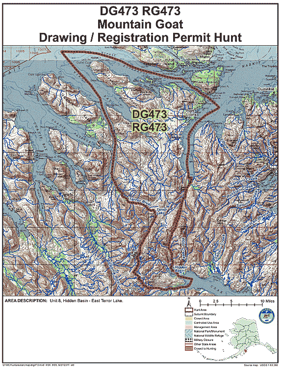
Hidden Basin - East Terror Lake
(USGS Maps - Kodiak B-4, C-4 & D-4)
Location:
Northern Kodiak Island, includes the west side of Hidden Basin Creek ,north to the west side of the west fork of the head waters of Kizhuyak Creek, Kupreanof Peninsula, Uganik Island, the east side of Terror River to Terror Lake, extending south to the east side of Mount Glottof to the southwestern arm of Ugak Bay. See area map (Image file 144 kB) for more information.
Land Ownership:
The majority of the goat habitat is state land with the area north of Terror Lake consisting mostly of U.S. Fish & Wildlife lands. See area map www.dnr.alaska.gov/mlw/planning/easmtatlas/kodiak/.
Access:
Excellent float plane access throughout hunt area. Some of the most popular lakes include Terror Lake, Buck Lake, Shotgun Lake, and Lake 2303.
Population Trend:
From 2013 to 2017 the population of goats in this area has ranged from 40 to 70 goats.
| Area | Hunt No. | Permits | % Draw (2017) |
|---|---|---|---|
| Hidden Basin - East Terror Lake | DG473 | 10 | 4% |
Mountain Goat Harvest Data:
DG473 (Draw Hunt)
| Year | Permits Issued | Hunters Afield | Harvest | % Success |
|---|---|---|---|---|
| 2017 | 12 | 10 | 7 total (4 male, 3 female) | 70% |
| 2016 | 12 | 9 | 6 total (5 male, 1 female) | 67% |
| 2015 | 12 | 8 | 6 total (4 male, 2 female) | 75% |
| 2014 | 12 | 6 | 5 total (4 male, 1 female) | 83% |
| 2013 | 12 | 4 | 1 total (1 male) | 25% |
| 2012 | 12 | 6 | 4 total (3 male, 1 female) | 67% |
| 2011 | 12 | 7 | 3 total (2 male, 1 female) | 43% |
| 2010 | 12 | 3 | 1 total (1 male) | 33% |
RG473 (Registration Hunt)
| Year | Permits Issued | Hunters Afield | Harvest | % Success |
|---|---|---|---|---|
| 2017 | 0 | 0 | 0 | NA |
| 2016 | 0 | 0 | 0 | NA |
| 2015 | 0 | 0 | 0 | NA |
| 2014 | 0 | 0 | 0 | NA |
| 2013 | 7 | 0 | 0 | NA |
| 2012 | 0 | 0 | 0 | NA |
| 2011 | 0 | 0 | 0 | NA |
| 2010 | 10 | 2 | 1 total (1 male) | 50% |