Kodiak Brown Bear Hunting Area 26
Kupreanof Peninsula
Drawing Hunt Designation
| Residency | Fall | Spring |
|---|---|---|
| Alaska Resident | DB 226 | DB 256 |
| Non Resident | DB 126 | DB 156 |
Area Description
(USGS Maps - Kodiak D-3 & D-4)
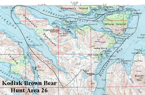
Location
Northern Kodiak Island, including the Viekoda Bay, Kupreanof Peninsula, Whale Island, Dry Spruce Island, Port Lions, and the area north of Barabara Lake. See area map (Image file 49 kB).
Topography and Habitat
Grass/salmonberry and cottonwoods flats dominate the lower elevations and river valleys. Hillsides are covered with dense alder thickets interspersed with grass/salmonberry meadows. Alpine areas start at 1500'. Inland area is composed to low ridges and foothills intersected by numerous drainages with a few small lakes. The northern portion of this area supports dense groves of spruce. The village of Port Lions (population 264) is included in this area and has regular air and ferry service. There is also and extensive system of ORV trails throughout the area. A powerline extends from the head of Kizhuyak Bay to Port Lions. Whale Island is mostly covered with spruce forest.
Land Ownership
Lands south of Viekoda Bay in Kodiak National Wildlife Refuge. There is mixed ownership of Kupreanof Peninsula, including State, Afognak Native Corporation, and private inholdings. Whale Island is mostly owned by Afognak Native Corporation.
Public Use Cabins
None.
Bear Harvest
2017 chance of being drawn
| Residency | Fall | Spring |
|---|---|---|
| Alaska Resident | 2% | 6% |
| Non Resident | 100% | 75% |
| Hunters Afield | Bears Harvested | Percent Males | Average Skull Size | |
|---|---|---|---|---|
| Fall 2017 | 6 | 3 | 67% | 23.54 |
| Spring 2017 | 8 | 2 | 50% | 24.84 |
| Fall 2016 | 6 | 1 | 100% | 26.56 |
| Spring 2016 | 6 | 4 | 75% | 23.44 |
| Fall 2015 | 7 | 3 | 67% | 24.96 |
| Spring 2015 | 3 | 1 | 100% | 20.19 |
| Fall 2014 | 5 | 1 | 0% | 23.69 |
Largest bear killed in this Hunt Area
29¾" (May 5, 1967)
"Green" measurement - Not Official
Guides registered for this Hunt Area (as of April 2018):
-
Brett Weaver
6938 Stella Place
Anchorage AK, 99507
(907) 770-8941
kodiakbearguides@yahoo.com -
Jason Bunch
556 Eli Waselie Circle
Kodiak, AK 99615
jkbunch@kodiakbackcountry.com -
Kevin Adkins
P.O. Box 50
Port Lions AK 99550
907-454-2418
info@kodiakwilderness.com -
Robert May
Box 32
Port Lions, AK 99550
(907) 454-2500
whalepasslodge@hotmail.com