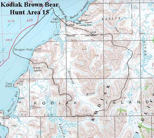
Kodiak Brown Bear Hunting Area 15
Sturgeon Bay
Drawing Hunt Designation
Exclusive Guide Area
| Residency | Fall | Spring |
|---|---|---|
| Alaska Resident | DB 215 | DB 245 |
| Non Resident | DB 115 | DB 145 |
Area Description
(USGS Maps - Karluk B-1, B-2 & C-2 )
Location
Southwestern Kodiak Island, including Sturgeon Lagoon, and most of the Sturgeon River drainage. See area map (Image file 62 kB).
Topography and Habitat
Moderately steep hills to 2490' surround the Sturgeon River. The river itself flows through a broad grass/salmonberry and tundra flat which is interspersed with alder and willow thickets.
Land Ownership
Lowlands along he river are owned by Koniag inc. Uplands are managed by Kodiak National Wildlife Refuge. There are also private inholdings along Sturgeon Lagoon.
Public Use Cabins
None.
Bear Harvest
2017 chance of being drawn
| Residency | Fall | Spring |
|---|---|---|
| Alaska Resident | 3% | 5% |
| Non Resident | 100% | 100% |
| Hunters Afield | Bears Harvested | Percent Males | Average Skull Size | |
|---|---|---|---|---|
| Fall 2017 | 3 | 0 | Not applicable | Not applicable |
| Spring 2017 | 3 | 3 | 100% | 26.35 |
| Fall 2016 | 5 | 0 | Not applicable | Not applicable |
| Spring 2016 | 6 | 2 | 100% | 26.69 |
| Fall 2015 | 3 | 1 | 100% | 28.38 |
| Spring 2015 | 3 | 2 | 100% | 27.72 |
| Fall 2014 | 3 | 0 | Not applicable | Not applicable |
Largest bear killed in this Hunt Area
29 15/16" (May 20, 1965)
"Green" measurement - Not Official
Guides registered for this Hunt Area (as of April 2018):
-
Paul Chervenak
P.O. Box 1961
Kodiak AK 99615
(907) 486-3008
Chervenak@gci.net