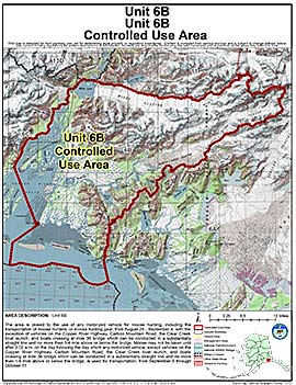
Controlled Use Areas
Unit 6(B) Controlled Use Area
Note: Use of these maps indicates that you have read and understand the liability statement.
Units: 06B
Area Description: Unit 6B
Restrictions: The area is closed to the use of any motorized vehicle for moose hunting, including the transportation of moose hunters, or moose hunting gear, from August 25 - September 4, with the exception of vehicles on the Copper River Highway, Carbon Mountain Road, the Clear Creek boat launch, and boats crossing at mile 36 bridge which can be conducted in a substantially straight line and no more than 1/4 mile above or below the bridge. Moose may not be taken until after 3:00 a.m. on the day following the day which any motorized vehicle, except vehicles on the Copper River Highway, Carbon Mountain Road, the Clear Creek boat launch, and boats crossing at mile 36 bridge which can be conducted in a substantially straight line and no more than 1/4 mile above or below the bridge, is used for transportation, from September 5 through October 31