Teller Highway
Mile 7–26 Snake River to Feather River Bridge
Habitat: Dwarf tundra, human-modified and river valley
The road moves away from lowland tundra and crosses rolling hills, small creeks, a major river and gives scenic views of tundra landscapes. Some road grades are steep and indicative of the deeply dissected short drainages characteristic of the southern Seward Peninsula. Each creek or river usually has a thin thread of dense vegetation that provides habitat, food, and refuge for mammal and bird species. The open tundra slopes have wind-swept waves of cotton grass showing their white blooming seed heads in early summer.
Notable Wildlife
- Muskoxen feed on sedges, wildflowers, and berries on side slopes and ridgelines.
- Reindeer are present in small groups in tundra meadows or on side slopes.
- Moose may be seen in areas of sparse willows.
- Rough-legged hawk, gyrfalcon, and common raven nest and perch on rocky outcrops along ridgelines.
- Wilson’s snipe is often heard in overhead display flights in May and June.
- Long-tailed jaeger, northern harrier and short-eared owl are common when voles, lemmings, or small birds are abundant.
- Snowy owl is present only in the rare years when lemmings are exceptionally plentiful.
- Northern wheatear is often seen at base of rocky slopes.
- Yellow warbler, Wilson’s warbler, tree sparrow, fox sparrow, white-crowned sparrow and golden-crowned sparrow prefer tall willows along the road.
Sledge Island view
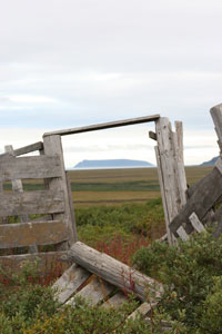
Sledge Island, seven miles off the coast, is visible on clear days from this section of Teller Highway. Originally named Ayak, the island was home to about 50 Ayakmiut, who primarily hunted seals but also walrus when they migrated close to shore. Captain Cook visited the island in 1778 and gave it an English name after a finely crafted Native-made sled (sledge) he admired there. The island’s steep cliffs provide ledges, crevices, and burrows for nesting kittiwakes, murres, and puffins often seen along Nome’s coast.
Mile 11.3 Abandoned reindeer corral
On the left as you head north are remnants of an abandoned reindeer corral first constructed by the Bureau of Indian Affairs in the 1970s for a reindeer herding demonstration project. The local Sitnasuak Native Corporation took over the corral in the early 1980s and ran a herd of about 750 animals for several years. The corral fell into disuse after Sitnasuak got out of the business and distributed the reindeer to other herders.
Mile 12.5 Penny River Bridge
Habitats: River valley and side slope
The Penny River has a narrow valley that has some braided channels below the bridge. The spring thaw floods the valley and tall willows close to the river show damage from surging high water and ice flows. The willows are resilient and re-grow making good browse for moose. In recent years beaver have been expanding their range and evidence of their feeding, cutting, damming and ponds are common in this drainage. The bridge crossing gives a good view of unusual birdlife and passage of salmon as they return to spawn each year.
Notable Wildlife
- Grizzly bears may be seen traversing slopes or feeding on salmon in late summer.
- Muskoxen may graze on slopes or seek out the river or tall willows on hot summer days.
- River otter are present but rarely seen. They may be spotted in early winter eating silver salmon carcasses.
- Red-breasted merganser and harlequin duck like the swift flowing water.
- Semipalmated plover and spotted sandpiper are seen along gravel shores.
- Arctic tern, mew gull, and glaucous gull are in flight or feeding along the river.
- Bank swallow excavates burrows in cut banks above high water and feeds on insects while in flight.
- American dippers are seen at river’s edge and sometimes nest under bridge.
- Arctic warblers flit back and forth across the river between the tall willows.
- Gray-cheeked thrush forage for food in open areas near willow thickets.
- Common redpoll and hoary redpoll are seen in this area.
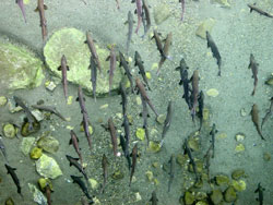
- Pink, chum, and silver salmon, Arctic grayling, and Dolly Varden are found in river.
Mile 13.6 – Possible raptor viewing
Habitat: Rock cliff, creek, ponds
As you drive towards Teller, the rocky outcrop on your right may host a nesting or perching site for rough-legged hawk, gyrfalcon, and common raven. From this spot you can look to your left down in the creek bottom to see an active beaver lodge with several dams and ponds.
Mile 15 House/Cabin Rock
Habitat: Dwarf tundra
House Rock and Cabin Rock are some of the local names for the obvious rock formation on the right. Arctic ground squirrel, locally called “parky squirrel,” is common on the dry, upper slopes of this hill. This location was once a popular ground squirrel trapping area when the skins were more in demand for clothing. Today, just a few master skin-sewers use their skill to painstakingly sew the pelts into women’s traditional fancy parkas.
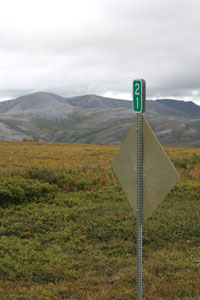
As the road crests the hill ahead of you, view the dramatic south face of the Kigluaik Mountain Range.
Notable Wildlife in Higher and Rockier Dwarf Tundra
- Muskoxen often gather on these windblown summits and ridgetops in winter.
- Rock ptarmigan are often found in a mix of dwarf shrubs and rocky rubble.
- Golden eagle, rough-legged hawk, gyrfalcon, and common raven perch or nest on rock outcrops and prominent high points.
- American golden-plover, northern wheatear, American pipit frequent the area.
Mile 19.4 - Cripple River Bridge
Habitat: River valley, tundra meadow, human-modified
The Cripple River has a steep road grade on either side that gives a good overview of the thin thread-like river that fills the valley. Gold mining activities occurred in the upper tributaries of the Cripple River, as evidenced by the road and horizontal ditch lines still visible on the upstream slopes. Old ditch lines and roadbeds continue to trap water and snow. The extra moisture encourages growth of taller shrubs and provides a small windbreak, attracting wildlife. An access road towards the coast begins near the bridge and crosses private land.
Notable Wildlife
- Harlequin ducks paddle in swift river currents. Look for females with young broods in late August or September.
- Pink salmon reach their upper spawning limit in the Cripple River.
- Dolly Varden fingerlings provide food for river otters in fall.
Mile 21 Turn-off
Habitat: Elevated slopes, tundra meadow, human-modified
 Heading north, a turn-off to a gravel pit on the right also offers off-road parking and access to tundra ridge hiking with great views of the surrounding area.
Mile 26 Sinuk River Bridge
Habitats: River valley and side slope
The Sinuk River is the largest river crossing on the Teller Road and the magnitude of the valley, river channels, rocky mountains and rolling tundra - all in one panoramic vista - is an impressive sight. It’s miles upstream to the nearest rock cliff but appears only a short distance away because of its size and color in an unimpeded view up the valley. The channels of the river shift from year to year making this place a window on the ever-changing aspects of river systems. Salmon runs make the bridge a reliable place to see several species as they return upriver in the summer season. Birdlife is dominated by species attracted to the flowing water and gravel bars, islands, and thick vegetation clustered in some sections of the river. Early season boating is possible when water levels are high but becomes questionable as the tundra dries out through the summer.
Notable Wildlife
- Moose tend to winter in taller willows in the lower river valley then move to higher drainages in summer.
- Reindeer graze the meadows in small groups.
- Harlequin duck and red-breasted merganser favor rocky edges and swift currents.
- Golden eagle, rough-legged hawk, gyrfalcon and common raven nest on cliffs in nearby locations and may fly overhead as they hunt for prey.
- Semipalmated plovers and ruddy turnstone use gravel bars in search of food.
- Glaucous gull, mew gull and Arctic tern congregate on the gravel bars and often perch on the bridge railing.
- Cliff Swallows build gourd-shaped mud nests under the bridge and swoop and dive while catching mosquitoes in flight.
- Red salmon travel 16 miles upriver to spawn in Glacial Lake in the heart of the Kigluaik Mountains.
- Chum, pink and silver salmon reach upper spawning limit about two miles above bridge.
- King salmon spawn in Sinuk River but rarely reach the bridge.
- Arctic grayling and Dolly Varden are also found in these waters.