Dall Sheep Hunting in Alaska
Delta Controlled Use Area Sheep Hunt DS203 and DS204
The Delta Controlled Use Area (DCUA) was created in 1971 to provide quality walk-in sheep hunting opportunities free from competition with other transportation types during the early portion of the sheep season. Because of ever-increasing hunting pressure, the area went to drawing permits in 1978. As is the case in most of the rest of the state, the bag limit is one ram with full curl or larger horns. Sheep hunting in this area is managed through two hunt periods, the DS203 (walk-in hunting only) from Aug. 10th – Aug. 25th , then the DS204 (unrestricted access) from Aug. 26th – Sept. 20th.
The use of motorized vehicles and pack animals in any manner for big game hunting is prohibited inside the Delta Controlled Use Area (DCUA) from Aug. 5th through Aug. 25th, this does not prohibit the use of motorized vehicles on the Richardson Highway or the Charlie Boyd Airstrip along the Johnson River (63 degrees 29.5 Minutes N. Latitude by 144 degrees 50.7 minutes W. Longitude) for accessing the hunt area or transporting game. From Aug. 26th to the close of sheep season on Sept. 20th; motorized access and the use of pack animals is allowed.
Description of the Area
The DCUA is bounded by the drainages of the Tanana River south of the Alaska Highway from the west bank of the Johnson River to and including the drainages into the Delta River north of Miller Creek. It includes the Castner Glacier (13B) and the Black Rapids Glacier (20A).
Johnson and Spur Glaciers area
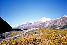
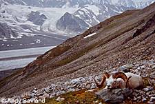
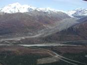
Water sources in the area are limited to glacial runoff or small snow patches that melt and are found in the small ravines draining off the side hills, also glacier ice. The area consists primarily of rugged mountains, many interspersed with or capped by glaciers. The Johnson Glacier and the area east lies within the Tok Management Area, and will contribute to additional human activity in the Johnson Glacier area.
Boat access up the Johnson River has been attempted in the past with little success. If attempted, should only be attempted by experienced boaters with glacial river knowledge and reliable equipment. Main access to the area is by super cub type aircraft. The Charlie Boyd airstrip lies just about a mile or more below the foot of the Johnson Glacier. The strip lies in a north/south direction and is roughly 700 feet in length and an elevation of about 2300 feet.
In 2011, DS203 hunt there were four hunters in this area with two being successful, while the DS204 hunt that same year seven hunters also hunted this area with four having success. Horn averages were 36.07" and 34.69" respectively.
In the 2010 DS203, six hunters and one ram harvested while the DS204 had seven hunters with four rams taken. Horn averages were 33.88" and 36.80" respectively.
In the 2009 DS203, eight hunters harvested two rams while the DS204 had ten hunters in the area harvest seven rams. Horn averages were 37.00" and 34.39" respectively.
Little Gerstle River
The Little Gerstle River hunt area is located north of the Johnson River and lies between the Gerstle River and Independent Ridge. There is a parking area at the pack trail head that is located at Mile 1388.4 Alaska Highway and leads south towards the mountains and the Johnson River. The trail is roughly 10 miles to Sheep Creek and 3 more to the Little Gerstle alluvial fan, then 6 to 8 miles up that drainage to the Little Gerstle glacier. Pegmatite Creek is the next drainage south.
These drainages will hold sheep and in recent years a small harvest has occurred. The trail is boggy and has several crossings of the Little Gerstle River.
In 2011 DS203 there were two hunters and both were successful with a horn average of 32.13" the DS204 had three hunting with 1 ram taken with a horn average of 36.63".
The 2010 DS203 three hunters had no success, while DS-204 there were three hunters and a harvest of two rams with a horn average of 37.50".
In 2009 DS203 had 1 hunter take a 35.25" ram, while during the DS204, one hunter was unsuccessful.
Gerstle Glacier and July Creek area
This area receives moderate to heavy hunting pressure. Moderate pressure during the Walk in season. Sheep habitat is about 15 miles in from the Alaska Hwy. The Gerstle Glacier and July Creek are about 25 miles in from the Alaska Hwy. There is a rough mining trail along the west side of the Gerstle River bottom, originating at the end of the Gerstle River Test Site Road located at mile 1394 on the Alaska Highway, just before the state campground. Most harvest occurs in the Bradford Creek, or July Creek areas. During the late season access to the Gerstle Glacier can be achieved by small super-cub type aircraft putting you in closer proximity to prime sheep habitat.
The 2011 DS203 season had twelve hunting with a harvest of five rams, the DS204 had thirteen parties hunt with a harvest of six rams. Horn averages were 33.91" and 36.03".
The 2010 DS203 had four hunters with two rams taken, and eleven hunters took five rams during the DS204 season. The horn averages were 37.81" and 33.52".
2009 season saw ten hunters take eight rams during the DS203, while the DS204 had ten hunters harvest three rams. The horn averages were 33.34" and 32.96".
Granite Mountain area
 This area is accessed by either the 12 Mile Crossing Trail at Mile 252.4 of the
Richardson Hwy. This access point crosses a portion of Ft. Greely, therefore you will
need to contact the USARTRAK for permission. The Recreational Access Permit (RAP) is free and can be obtained at
https://usartrak.isportsman.net/, access can also be found along the Alaska Highway at Mile 1408
which will lead to Rhoads Creek, or at mile 1402 which will lead to Hajdukovich Creek
and eventually to the Jagged Boulder Plateau area. There are several small lakes that
provide water and you can also obtain water from some of the many year around snow
packs in the protected ravines.
This area is accessed by either the 12 Mile Crossing Trail at Mile 252.4 of the
Richardson Hwy. This access point crosses a portion of Ft. Greely, therefore you will
need to contact the USARTRAK for permission. The Recreational Access Permit (RAP) is free and can be obtained at
https://usartrak.isportsman.net/, access can also be found along the Alaska Highway at Mile 1408
which will lead to Rhoads Creek, or at mile 1402 which will lead to Hajdukovich Creek
and eventually to the Jagged Boulder Plateau area. There are several small lakes that
provide water and you can also obtain water from some of the many year around snow
packs in the protected ravines.
This area in the past has not received much hunting pressure due to low numbers of legal rams, but in recent years sheep numbers have increased and we have seen more success from hunters.
The 2011 results for the DS203 saw two successful hunters out of five, while the DS204 had four hunters with a harvest of three rams. Horn averages were 36.07" and 34.04".
The 2010 DS203 had four hunters harvest three rams and the DS204 had six hunters in this area with a harvest of one ram. Horn averages were 35.84" and 35".
The 2009 results for the DS203 were three hunters with a harvest of one ram while the DS204 was similar with three hunters and the harvest was one ram. Horn averages were 39" and 34.25".
Jarvis and Riley Creek areas
This area is accessed along the Richardson Highway at the Coal Mine Road at Mile 242.6 or at the Twelve Mile Crossing trail at mile 252.4(This access point crosses a portion of Ft. Greely, therefore you will need to contact the USARTRAK for permission. The RAP is free and can be obtained at https://usartrak.isportsman.net/, both these trails will lead to the Jarvis Creek area, also the Morningstar and McCumber Creeks. This portion of the DCUA receives the most hunt pressure during both hunts, primarily because of the access and the terrain is less rugged, although the Jarvis and Riley Creek Glaciers are fairly rugged and steep. Water sources are limited in this area. Sheep numbers in these areas are some of the highest, which contributes to most of the harvest for the 2 seasons.
2011 had five parties hunting with a harvest of three rams, while the DS204 had sixteen hunters with a harvest of nine rams, horn averages were 35.5" and 34.36".
The 2010 seasons saw eighteen hunters in the DS203 harvest seven rams, while the DS204 saw eight hunters harvest two rams, horn averages were 36.82" and 33.51".
During the 2009 season we had a harvest of four rams from ten hunters in the DS203, while the DS204 saw a harvest of ten rams from fifteen hunters, horn average was 35.63" and 34.68".
Darling, Bear, One-Mile, Flood, Whistler, and Trimms Creeks
These numerous small tributaries of the Delta River are easily accessible off the Richardson Highway. Although these creeks are fairly short in length and rise in elevation quickly to sheep habitat, numbers of sheep utilizing them are low therefore they receive minimal pressure from hunters. Reports in the past reflect almost no harvest out of these drainages, although full curl rams have on occasion, come out of these creeks. Most hunters only see ewes, lambs and young rams. These creeks are prone to flash flooding during periods of heavy rain.
In 2011, the DS203 had two rams harvested out of seven hunters, and the DS204 had one ram harvested out of four hunters, and horn averages were 37.88" and 36".
The 2010 DS203 had two hunters but no harvest, while the DS204 had two rams harvested out of three hunters, the horn average was 38.57".
The 2009 DS203 showed a surge of eight hunters that year with three rams taken while the DS204 was two for two, horn averages were 36.17" and 35.94".
Castner, Canwell and Triangle Peak area
Easiest access to sheep habitat, with this area two to three miles off the Richardson Hwy. and you're in sheep country, eight to ten miles and you start to run out of their habitat. The Canwell Glacier is not in the DCUA but in a general hunt area. A hunter a would need General SHEEP harvest ticket to harvest a ram in this area, because the draw permit is only good for hunting sheep within the DCUA.
2011 DS203 in this area saw ten hunters harvest one ram, while the DS204 saw two hunters with one ram taken, horn average was 37.5" and 33.75".
The 2010 DS203 had eight hunters with a harvest of two rams and the DS204 had nine hunters with a harvest of three rams, horn averages were 34.25" and 37.5".
The 2009 DS203 had seven hunters take one ram, and the DS204 had eleven hunters with four rams harvested, the horn averages were 36.75" and 35.71".
Black Rapids and McGinnis Glacier areas
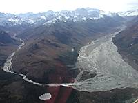
 This is an area of the DCUA that provides the most difficulty to hunt
primarily getting across the Delta River, during the early season this is
usually attempted by raft or canoe either a few miles above or below the
Class V whitewater of Black Rapids, the downstream crossing would be
the safer of the two. The terrain is extremely rugged, so most hunters
will try to ascend the glacier and proceed up it until reaching a suitable
area to get off the glacier, this in it's self can be difficult and also dangerous
if one attempts it in the wrong place. Most of the ram harvest here is on
the north side of the glacier, and in the Mt. Pillsbury and McGinnis Glacier
areas.
This is an area of the DCUA that provides the most difficulty to hunt
primarily getting across the Delta River, during the early season this is
usually attempted by raft or canoe either a few miles above or below the
Class V whitewater of Black Rapids, the downstream crossing would be
the safer of the two. The terrain is extremely rugged, so most hunters
will try to ascend the glacier and proceed up it until reaching a suitable
area to get off the glacier, this in it's self can be difficult and also dangerous
if one attempts it in the wrong place. Most of the ram harvest here is on
the north side of the glacier, and in the Mt. Pillsbury and McGinnis Glacier
areas.
Weather in this area can change very rapidly due to the size of the mountains and glaciers in close proximity to the divide.
The 2011 DS203 in this area saw four hunters harvest two rams, while the DS204 saw four hunters in the area with a harvest of two rams, horn averages were 32.75" and 38.26".
The 2010 DS203 had six hunters in the area with a harvest of two rams, while the DS204 had two hunters in the area with no harvest, and the horn average was 36.88".
The 2009 DS203 had seven hunters with a harvest of three rams and DS204 reported two hunters with one ram harvested, the horn averages were 37.83" and 40.25".
Field Evaluation of Sheep
In many respects, the field identification of a trophy-quality mountain sheep is easier than most other North American big game. Normally, there may be other rams in a bunch to provide a comparison between the trophy which initially looks best and those present of lesser quality. Nevertheless, if the rams are all within the same approximate age group, as frequently happens, one may easily be misled.
The fact is that a real trophy ram is instantly recognizable by anyone familiar with wild sheep. If one is inclined to hesitate as to whether the trophy is of world record class, don't shoot. Inevitably it will fall short.
What, then, does one look for to identify a ram of probable trophy class. In the first instance, never make a judgment when the ram is facing away. Any ram will look much bigger than it actually is when viewed from behind. One must have a full frontal view to be sure. Even a broadside view is not adequate. The lower curve of the horn of a trophy-quality ram will always drop below the line of the chin. The deeper the curl at this point, the more likely the horns are to meet or exceed the current minimum entry scores for the Boone and Crockett , or Pope and Young. One often sees rams with more than a full curl where the bottom line of the descending horn fails to approximate the bottom surface of the jaw bone. Such trophies may readily measures on the curl from 36 to 39 inches. They seldom measure 40 inches and larger. In any event, it is very, very seldom that the weight of the horn on such a trophy will carry out far enough to produce good second and third quarter circumferences. Many are indeed beautiful, even magnificent trophies, but probably not records book size. A close check on the weight of the horns at the second and third quarters can generally only be done with a good side-view examination, but it is needed to properly identify a trophy ram.
These comments emphasize the need to take one's time in judging a ram. Sometimes circumstances really do not favor that deliberation. If the ram is bedded down, there is a far greater risk of error than if he is up and about and moving his head while grazing.
Let us assume that a ram displays a full curl of the usual configuration found in the Dall Sheep. If the bottom of the curl approximates the line of the lower jaw and rises to the level of the nostril, these horns are likely to run about 35 inches in length. If the same horns carry there lambing tips two to three inches above the eyes, you may be looking at a 37 or 38 inch horn.
Finally, a high-powered spotting scope will often enable one too roughly count the growth rings on the horns. A true trophy sheep will almost always prove to be from 10 to 13 years old. They seldom live longer than that. Therefore, should one find a solitary old ram on some high mountain pasture, an evident outcast of the herd, there is little doubt that it is of trophy quality. Most guides who take sheep hunters out are good judges of heads, but it is most enjoyable for the hunter to be able to judge them himself. If anyone is interested in sheep trophies I think he should make it a point to observe carefully every mounted sheep head he encounters. He should ask how it measures or should measure it himself- with the owners permission, of course.
The sheep hunter often has the opportunity to look rams over carefully through a spotting scope. On the other hand, he may suddenly have to decide which ram to take out of a running band. A very large head always looks very large to a hunter of experience. A small one looks small.
But here are things to look for. In the first place, those cliches of the beginning sheep hunter, the " full curl" and "perfect points," mean next to nothing. Many horns make a full spiral are on young sheep that should be left to grow up.
The thing to look for in the sheep head is mass. The really great ram appears to be all horns. He looks top heavy. It makes no difference as to the type of head - close-curl, medium - curl, argali, widespread, or droopy- the great horns look great instantly to the hunter of experience.
If a pair of broken horns come down below the point of the jaw and up to the bridge of the nose, the head is an extra good one. If the ends of the broken horns continue above the bridge of the nose the head is a very good one, will probably be in the record book, and is worth considerable pains to collect.
If, on the other hand, the horns look light, curve above the point of the jaw, and have perfect points, the ram is a young one and should not be shot- even if the tips of the horns come well above the bridge of the nose.
If the horns have a medium or close curl, go below the point of the jaw and up to the bridge of the nose, are somewhat broken and look fairly heavy, they will probably measure 37 1/2 to 38 1/2 inches around the curls. Such a head is one no one need be ashamed of. It is from a ram probably ten years old or older. He has pretty well lived his life and discharged his duty to his kind.
Air Taxi Operators
Golden Eagle Outfitters: (907) 895-4139 DELTA JCT.
Mt. Hayes Air: (907) 895-5331 DELTA JCT.
40 Mile Air: (907) 883-5191 TOK
Delta Controlled Use Area (DCUA)sheep horn averages by drainage
DS203
| Area | 2017 | 2016 | 2015 | 2014 | 2013 | 2012 | 2011 | 7 Year Avg. |
|---|---|---|---|---|---|---|---|---|
| Black Rapids | 36.1" | 34.5" | 35" | 35.68" | 30.38" | 36.13" | 32.75" | 34.36" |
| Castner/Canwell | 37.38" | 0 | 38.75" | 35.75" | 33.85" | 34.21" | 37.5" | 36.24" |
| Jarvis/Riley Ck. | 34.82" | 36.19" | 33.25" | 34.83" | 33.71" | 36.58" | 35.5" | 34.98" |
| Granite Mountain | 0 | 34.38" | 35.63" | 33.44" | 37.82" | 0 | 36.07" | 35.47" |
| Gerstle River/July Ck. | 34.13" | 34.2" | 35.03" | 33.44" | 36.32" | 34.85" | 33.91" | 34.55" |
| Little Gerstle River | 0 | 36" | 32.88" | 0 | 0 | 32.88" | 32.13" | 33.47" |
| Johnson/Spur Glacier | 35.25" | 36.45" | 35.66" | 0 | 32.38" | 36.03" | 36.07" | 35.31" |
| Richardson Highway | 34.33" | 34.32" | 36.88" | 33.5" | 36.25" | 31.38" | 37.88" | 34.93" |
DS204
| Area | 2017 | 2016 | 2015 | 2014 | 2013 | 2012 | 2011 | 7 Year Avg. |
|---|---|---|---|---|---|---|---|---|
| Black Rapids | 35.92 | 37.33 | 0 | 0 | 33 | 35.38 | 38.26 | 35.98 |
| Castner/Canwell | 0 | 0 | 35.25 | 35.94 | 0 | 0 | 33.75 | 34.98 |
| Jarvis/Riley Ck. | 35 | 37.04 | 34.5 | 35.38 | 31.86 | 33 | 34.36 | 34.45 |
| Granite Mountain | 37.07 | 0 | 38.5 | 0 | 32.53 | 35.5 | 34.04 | 35.53 |
| Gerstle River/July Ck. | 34.46 | 34.35 | 0 | 32.84 | 34.21 | 35.58 | 36.03 | 34.58 |
| Little Gerstle River | 0 | 0 | 38 | 35.25 | 0 | 0 | 36.63 | 36.63 |
| Johnson/Spur Glacier | 36.55 | 36.81 | 35.31 | 35.88 | 31.01 | 35.18 | 34.69 | 35.06 |
| Richardson Highway | 36.63 | 36.62 | 36.75 | 35.75 | 33 | 34.32 | 36 | 35.58 |