Areas With Restrictions
Search By Game Management
Unit (GMU)
Note: Use of these maps indicates that you have read and understand the liability statement.
Select a Game Management Unit.
Game Management Unit
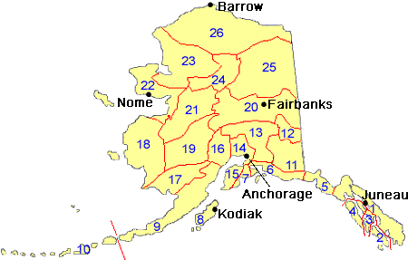
Results for Game Management Unit 26
The following restrictions are those specific to GMU 26. Be sure to check the hunting regulations for additional state-wide hunting and trapping restrictions.
You can check the current status of closures on military land at https://usartrak.isportsman.net/.
Areas Closed to Hunting
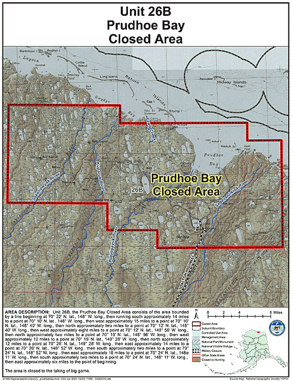
Prudhoe Bay Closed Area
- Restriction: Closed to the taking of big game
- View Map: GIF Map (136 K) PDF Map (332 K)
- Area Description: Unit 26 the Prudhoe Bay Closed Area is closed to the taking of big game; this closed area consists of the area bounded by a line beginning at 70° 22' N. lat., 148° W. long., then running south approximately 14 miles to a point at 70° 10' N. lat., 148° W. long., then west approximately 15 miles to a point at 70° 10' N. lat., 148° 40' W. long., then north approximately two miles to a point at 70° 12' N. lat., 148° 40' W. long., then west approximately eight miles to a point at 70° 12' N. lat., 148° 56' W. long., then north approximately two miles to a point at 70° 15' N. lat., 148° 56' W. long., then west approximately 12 miles to a point at 70° 15' N. lat., 149° 28' W. long., then north approximately 12 miles to a point at 70° 26' N. lat., 149° 28' W. long., then east approximately 14 miles to a point at 70° 26' N. lat., 148° 52' W. long., then south approximately two miles to a point at 70° 24' N. lat., 148° 52' W. long., then east approximately 16 miles to a point at 70° 24' N. lat., 148° 11' W. long., then south approximately two miles to a point at 70° 24' N. lat., 148° 11' W. long., then east approximately six miles to the point of beginning
Controlled Use Areas
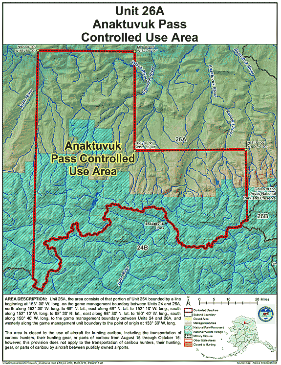
Anaktuvuk Pass Controlled Use Area
- Restriction: The area is closed to the use of aircraft for hunting caribou, including the transportation of caribou hunters, their hunting gear, or parts of caribou from August 15 through October 15; however, this provision does not apply to the transportation of caribou hunters, their hunting gear, or parts of caribou by aircraft between publicly owned airports.
- View Map: GIF Map (122 K) PDF Map (486 K)
- Area Description: Anaktuvuk Pass Controlled Use Area: the area consists of that portion of Unit 26(A) bounded by a line beginning at 153° 30' W. long. on the game management boundary between Units 24 and 26(A), north along 153° 30' W. long. to 69° N. lat., east along 69° N. lat. to 152° 10' W. long., south along 152° 10' W. long. to 68° 30' N. lat., east along 68° 30' N. lat. to 150° 40' W. long., south along 150° 40' W. long. to the game management boundary between Units 24 and 26(A), and westerly along the game management unit boundary to the point of origin at 153° 30' W. long.
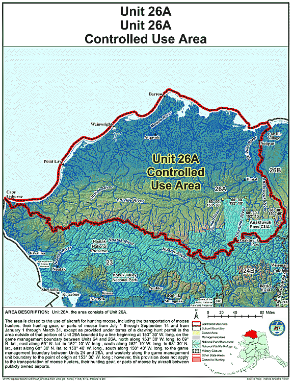
Unit 26(A) Controlled Use Area
- Restriction: The area is closed to the use of aircraft for hunting moose, including the transportation of moose hunters, their hunting gear, or parts of moose from July 1 through September 14 and from January 1 through March 31, except as provided under terms of a drawing hunt permit in the area outside of that portion of Unit 26(A) bounded by a line beginning at 153° 30' W. long. on the game management boundary between Units 24 and 26(A), north along 153° 30' W. long. to 69° N. lat., east along 69° N. lat. to 152° 10' W. long., south along 152° 10' W. long. to 68° 30' N. lat., east along 68° 30' N. lat. to 150° 40' W. long., south along 150° 40' W. long. to the game management boundary between Units 24 and 26(A), and westerly along the game management unit boundary to the point of origin at 153° 30' W. long.; however, this provision does not apply to the transportation of moose hunters, their hunting gear, or parts of moose by aircraft between publicly owned airports.
- View Map: GIF Map (111 K) PDF Map (373 K)
- Area Description: The Unit 26(A) Controlled Use Area: the area consists of Unit 26(A)
Management Areas
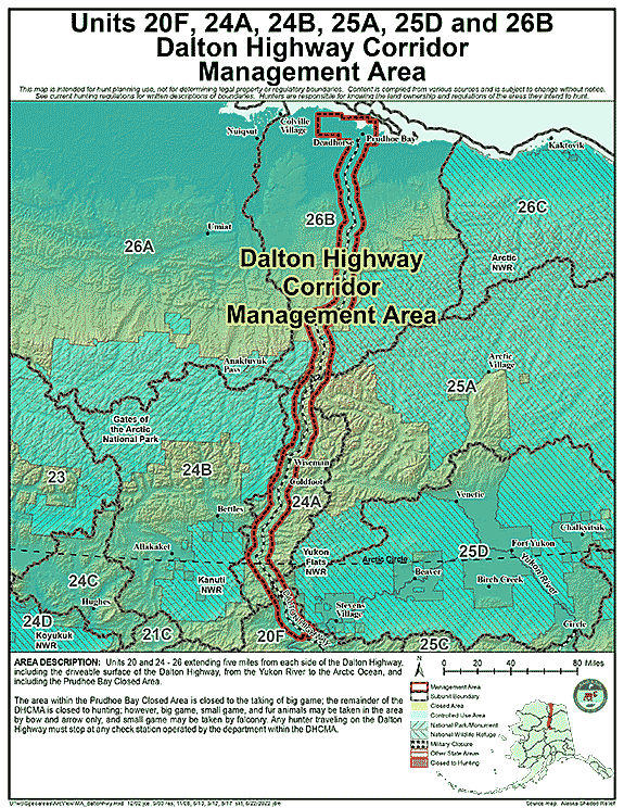
Dalton Highway Corridor Management Area
- Restriction: The area within the Prudhoe Bay Closed Area is closed to the taking of big game; the remainder of the DHCMA is closed to hunting; however, big game, small game, and fur animals may be taken in the area by bow and arrow only, and small game may be taken by falconry.
Any hunter traveling on the Dalton Highway must stop at any check station operated by the department within the DHCMA - View Map: GIF Map (137 K) PDF Map (657 K)
- Area Description: Dalton Highway Corridor Management Area (DHCMA): the portions of Units 20 and 24-26 extending five miles from each side of the Dalton Highway, including the driveable surface of the Dalton Highway, from the Yukon River to the Arctic Ocean, and including the Prudhoe Bay Closed Area
Note: Changes to area restrictions for hunting and trapping by Emergency Orders may not be shown on this page. Please be sure to check the Emergency Orders page for the most current list of changes.