Management Areas
Minto Flats Management Area
Note: Use of these maps indicates that you have read and understand the liability statement.
Units: 20
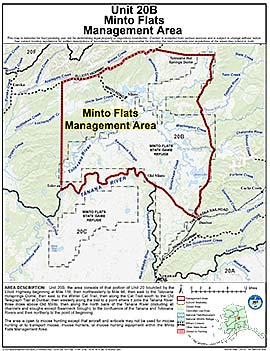
Area Description: Minto Flats Management Area: the area consists of that portion of Unit 20 bounded by the Elliott Highway beginning at Mile 118, then northeasterly to Mile 96, then east to the Tolovana Hotsprings Dome, then east to the Winter Cat Trail, then along the Cat Trail south to the Old Telegraph Trail at Dunbar, then westerly along the trail to a point where it joins the Tanana River three miles above Old Minto, then along the north bank of the Tanana River (including all channels and sloughs except Swanneck Slough), to the confluence of the Tanana and Tolovana Rivers and then northerly to the point of beginning
Restrictions: Open to moose hunting except that aircraft and airboats may not be used for moose hunting or to transport moose, moose hunters, or moose hunting equipment within the Minto Flats Management Area