Management Areas
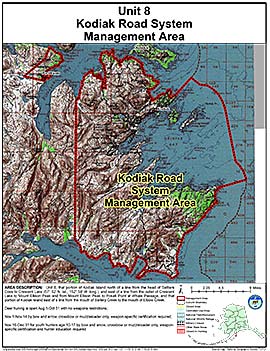
Kodiak Road System Management Area
Note: Use of these maps indicates that you have read and understand the liability statement.
Units: 08
Area Description: Unit 8, Kodiak Island north of a line from the head of Settlers Cove to Crescent Lake (57°52'N, 152°58'W) including Peregrebni Peninsula, and east of a line from the outlet of Cresent Lake to Mount Ellison Peak and from Mount Ellison Peak to Pokati Point at Whale Passage, and that portion of Kodiak Island east of a line from the mouth of Saltery Creek to the mouth of Elbow Creek and adjacent small islands in Chiniak Bay
Restrictions: Deer huning is open Aug 1-Oct 31 with no weapons restrictions;
Nov 1-Nov 14 by bow and arrow, crossbow or muzzleloader only, weapon-specific certification required;
and Nov 16-Dec 31 for youth hunters age 10-17 by bow and arrow, crossbow or muzzleloader only, weapon-specific certification and hunter education required