Controlled Use Areas
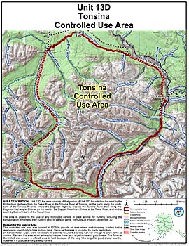
Tonsina Controlled Use Area
Note: Use of these maps indicates that you have read and understand the liability statement.
Units: 13D
Area Description: The Tonsina Controlled Use Area: the area consists of that portion of Unit 13(D) bounded on the west by the Richardson Highway from the Tiekel River to the Tonsina River at Tonsina, on the north along the south bank of the Tonsina River to where the Edgerton Highway crosses the Tonsina River, then along the Edgerton Highway to Chitina, on the east by the Copper River from Chitina to the Tiekel River, and on the south by the north bank of the Tiekel River
Restrictions: Closed to the use of any motorized vehicle or pack animal for hunting, including the transportation of hunters, their hunting gear, or parts of game, from July 26 through September 30