Controlled Use Areas
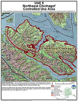
Northeast Chichagof Controlled Use Area
Note: Use of these maps indicates that you have read and understand the liability statement.
Units: 04
Area Description: Unit 4, the area consists of that portion of Unit 4 on Chichagof Island north of Tenakee Inlet and east of the drainage divide from the northwest point of Gull Cove to the Port Frederick Portage, including all drainages into Port Frederick and Mud Bay
Restrictions: Closed to the use of any motorized land vehicle for brown bear hunting, including the transportation of brown bear hunters, their hunting gear, or parts of brown bears, except as provided under terms of a registration hunt permit