Controlled Use Areas
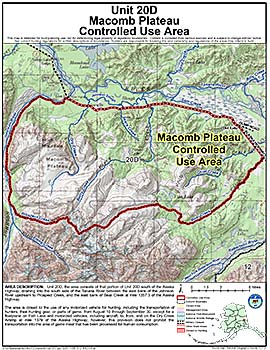
Macomb Plateau Controlled Use Area
Note: Use of these maps indicates that you have read and understand the liability statement.
Units: 20D
Area Description: The Macomb Plateau Controlled Use Area: the area consists of that portion of Unit 20(D) south of the Alaska Highway, draining into the south side of the Tanana River between the east bank of the Johnson River upstream to Prospect Creek, and the east bank of Bear Creek at mile 1357.3 of the Alaska Highway
Restrictions: The area is closed to the use of any motorized vehicle for hunting, including the transportation of hunters, their hunting gear, or parts of game, from August 10 through September 30, except for a floatplane on Fish Lake and motorized vehicles, including aircraft, to, from, and on the Dry Creek Airstrip at mile 1379 of the Alaska Highway; however, this provision does not apply to the transportation into the area of game meat that has been processed for human consumption.