Areas Closed to Trapping
Unit 1(C) Trails
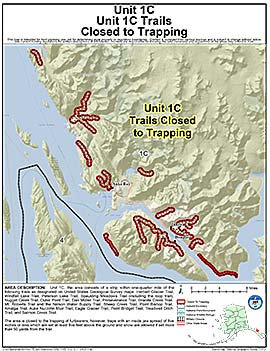
Note: Use of these maps indicates that you have read and understand the liability statement.
Units: 01C
Area Description: Unit 1(C) a strip within one-quarter mile of the following trails as designated on United States Geological Survey maps: Herbert Glacier Trail, Windfall Lake Trail, Peterson Lake Trail, Spaulding Meadows Trail (including the loop trail), Nugget Creek Trail, Outer Point Trail, Dan Moller Trail, Perseverance Trail, Granite Creek Trail, Mt. Roberts Trail and the Nelson Water Supply Trail, Sheep Creek Trail, Point Bishop Trail, Amalga Trail, Auke Nu/John Muir Trail, Eagle Glacier Trail, Point Bridget Trail, Treadwell Ditch Trail, and Salmon Creek Trail
Restrictions: Closed to the trapping of furbearers; however, traps with an inside jaw spread of five inches or less which are set at least five feet above the ground and snow are allowed if set more than 50 yards from the trail