Areas Closed to Hunting
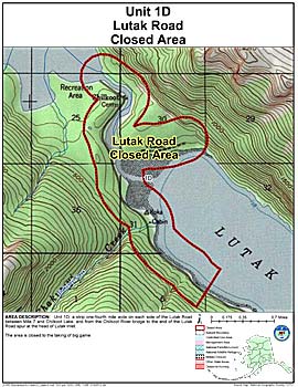
Lutak Road Closed Area
Note: Use of these maps indicates that you have read and understand the liability statement.
Units: 01D
Area Description: Unit 1(D) a strip one-fourth mile wide on each side of the Lutak Road between Mile 7 and Chilkoot Lake, and from the Chilkoot River bridge to the end of the Lutak Road spur at the head of Lutak Inlet
Restrictions: Closed to the taking of big game