
Commercial Salmon Fisheries
Kodiak Management Area Weir Locations
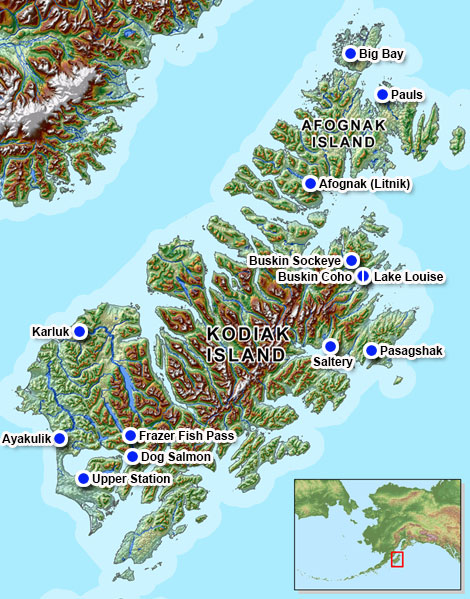
The Big Bay Creek weir is approximately 9 m (30') long and is located at the head of Big Bay on the west side of Shuyak Island. First constructed in 1988, the weir is normally operated by volunteers and employees of the Alaska Department of Natural Resources (ADNR) Division of State Parks from early August to mid-September. ADF&G Commercial Fisheries Management provides weir materials and logistical support. The Big Bay Creek weir was not operated in 1997, 1999 and 2003 to 2006.
The Litnik (Afognak River) weir is approximately 27 m (88') long and is located about 0.8 km (0.5 mi) above the outlet of the Afognak River, which flows into Afognak Bay, on the south end of Afognak Island. A weir was first constructed in 1921, at a site located approximately 0.64 km (0.4 mi) below the outlet of Afognak Lake, where intermittent weir counts occurred up to 1978, then annually until 1985. In 1986 it was moved to its current location and has been operated there since. The Litnik weir is operated by two ADF&G Commercial Fisheries Division employees from late May to mid-September.
The Buskin River weir is approximately 38 m (125') long and was first constructed in 1985 approximately 1.6 km (1 mi) above the outlet of the Buskin River, which flows into Chiniak Bay on the northeast side of Kodiak Island. In 1990, a 33 m (109') weir was constructed at the outlet of Buskin Lake, approximately 6.4 km (4 mi) above the lower weir site. This location was chosen to avoid the frequent washouts that occurr at the lower site and to assure a consistent and accurate count of sockeye salmon from mid-May through late July. In past years, the weir is moved annually from the upper site to the lower site in late July or early August to obtain an accurate coho salmon count. In 2010, two ADF&G Sport Fish Division employees operated the upper weir from May 21 to October 7 and the lower weir from July 29 to September 29. Escapement counts for sockeye salmon and steelhead are measured at the upper weir while the Chinook, coho, pink, and chum salmon are measured at the lower weir. Because the Lake Louise weir is upstream of the lower Buskin weir site but the confluence of Lake Louise is below the Lake weir site, the escapement for the Buskin River drainage is considered to include the Buskin River weir cumulative counts plus the sockeye salmon cumulative counts through Lake Louise weir.
The Lake Louise weir is 9 m (30') long and is located approximately 0.8 km (0.5 mi.) above the confluence of the Buskin River and the tributary creek draining Lake Louise. A weir was used in this location in the 1970s and 1980s to estimate out migrating juvenile salmon abundance, and a Dolly Varden mark-recapture study in 1992. Since 2002, the Lake Louise weir has been operated from approximately June 1 through September 15 by two ADF&G Sport Fish Division employees who are also responsible for the operation and maintenance of the Buskin River weir.
The Saltery River weir is approximately 37 m (120') long and is located about 0.4 km (one-quarter of a mile) below the outlet of Saltery Lake, on the northeast side of Kodiak Island. Saltery weir was first constructed and installed in 1985. During the first 3 years of operation, it was placed in various locations closer to the lagoon. In 1988, it was moved to its present location due to instability and a shifting river bed and operated there until 2003 and again from 2008 through 2010. In 2010, the Saltery weir was operated by two KRAA employees and supervised by an ADF&G project biologist from early June to early August.
The Karluk River weir is approximately 101 m (330\’) long and is located about 1.3 km (0.8 mi) upstream of the confluence of the Karluk River and Karluk Lagoon, on the southwest side of Kodiak Island. The weir was first constructed in 1921 at its current location and was operated annually at this location until 1941. The weir was moved to "the portage," approximately 12.9 km (8 mi) downriver from the Karluk Lake outlet from 1942 to 1945. Between 1946 and 1975 it was operated at the outlet of Karluk Lake. It was re-established at its present location in 1976. The weir is operated by two to four ADF&G Commercial Fisheries Division employees from mid-May to late September. In 2010, one ADF&G Sport Fish Division employee assisted with weir operations during the Chinook salmon run from mid-May until approximately July 15.
The Frazer fish pass consists of a diversion weir and a series of "fish ladders". The diversion weir directs fish to the entrance of the fish pass. The fish pass is a series of raceways 60 m (197') long with a gradual slope of 22%. This allows salmon to ascend a barrier falls approximately 9 m (30') tall, which are located near the outlet of Frazer Lake on the Dog Salmon Creek at the south end of Kodiak Island. Counts are made at the upstream portion of the fish pass. Constructed in 1962 to accommodate sockeye salmon stocks introduced in 1951. In 2010, the fish pass was operated by two Kodiak Regional Aquaculture Association(KRAA) funded employees and supervised by an ADF&G project biologist from mid-May to mid-August. Frazer Lake sockeye salmon are first counted through the Dog Salmon Creek weirs to manage commercial fisheries in the Alitak District. The salmon are then counted again as they exit the fish pass to ensure a sustainable population reaches Frazer Lake.
The Dog Salmon Creek weir project consists of three weirs, 38 m (125'), 41 m (135'), and 8 m (25') in length, on the three lower forks of the Dog Salmon Creek, 0.5 km (0.3 mi) upstream of their outlets into Olga Bay, on the south end of Kodiak Island. The Dog Salmon Creek flows from Frazer Lake. First constructed in 1983, the weirs are usually operated by two ADF&G Commercial Fisheries Division employees from early June to late August.
The Upper Station (Olga Creek) weir is approximately 11 m (35') long and is located near the outlet of Olga Creek where it drains into upper Olga Bay, on the south end of Kodiak Island. The weir was first constructed in 1929 just above the lagoon, approximately 0.23 km (0.14 mi) upstream of its current location, and was operated there until 1969. From 1969 to 1992, the weir was operated near the outlet of lower South Olga Lake. The weir was moved to its current location in 1993. The weir is operated by two ADF&G Commercial Fisheries Division employees from late May to mid-September. The Upper Station system has two distinct runs of sockeye salmon; an early run prior to and including 15 July, and a late run which occurs post 15 July.
The Ayakulik River weir is approximately 35 m (120'') long and is located about 1.3 km (0.8 mi) upstream from the outlet of the Ayakulik River into the Shelikof Strait, on the southwest side of Kodiak Island. Ayakulik River weir was originally constructed in 1929 at the outlet of Red Lake and operated at that location until 1969. The weir has been at its current location since 1970. The weir is operated by two ADF&G Commercial Fisheries Division employees from late May to early September. In 2010, one ADF&G Sport Fish Division employee assisted with weir operations during the Chinook salmon run from mid-May until approximately 15 July.