Fish Passage Site 10302262
Coordinates (dec. deg.): 58.42736°, -135.77742°
Legal Description: C040S058E02
Region: Southeast
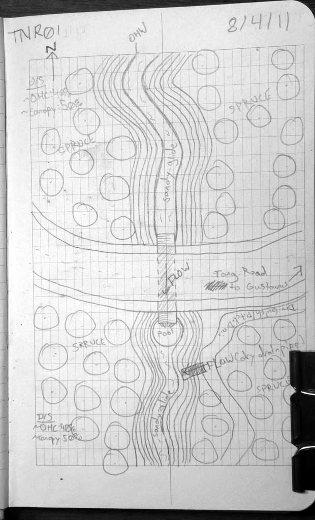
Road Name: Tong Road
Datum: NAD83
Quad Name / ITM: Juneau B-6
AWC Stream #:
Stream Name: Good River tributary
Elevation:
Site Comments: None
Survey SEA11-TNR01
Project Supervisor: Gillian O'Doherty, Alaska Department of Fish and Game
— Anchorage, AK
Observers: Jason Olds, Charmagne Gutierrez
Overall Fish Passage Rating:
Tidal: No
Backwatered: No
Step Pools: No
Construction Year:
Site Observations:
- Outfall height red
- Constriction ratio gray
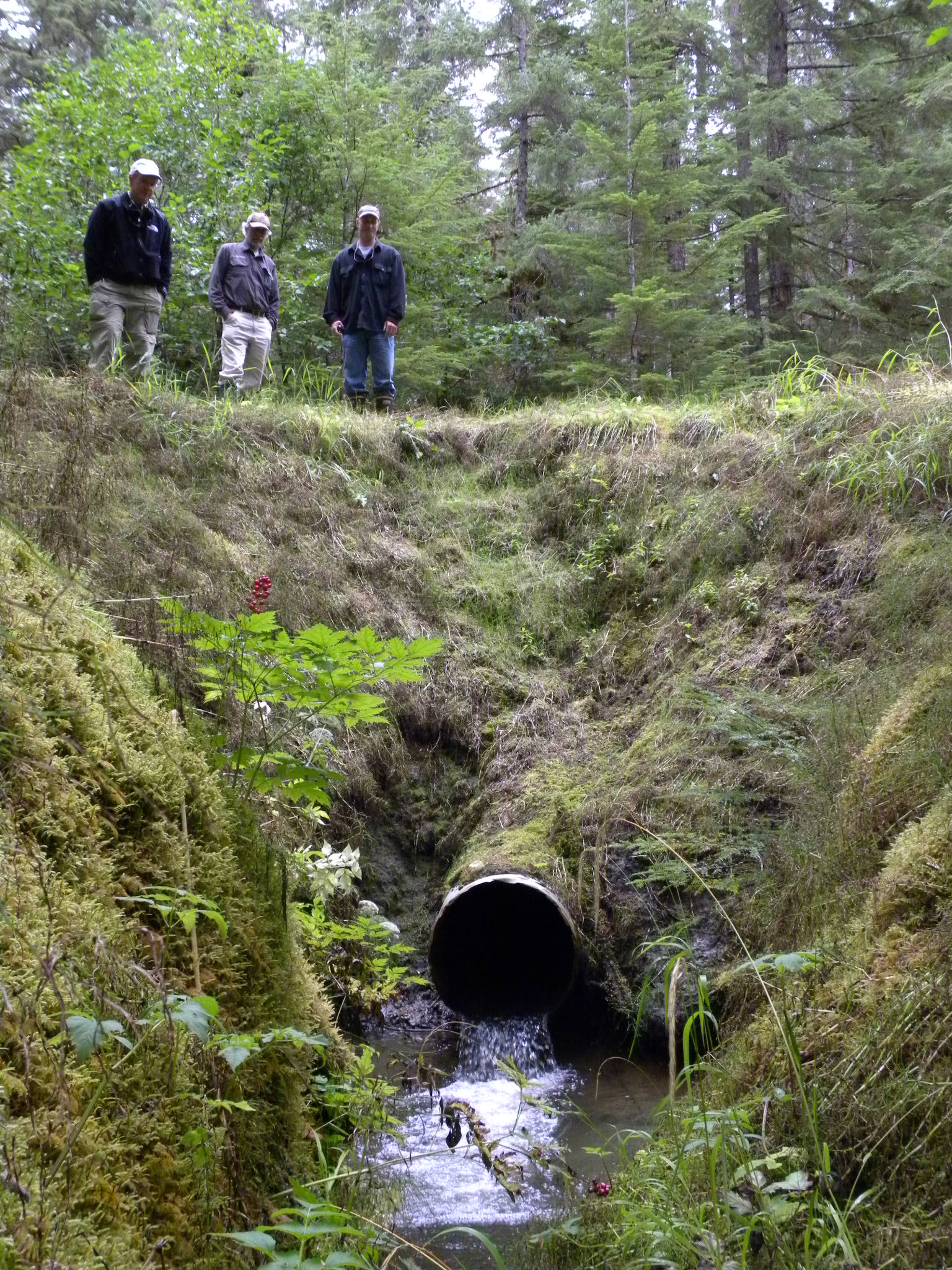
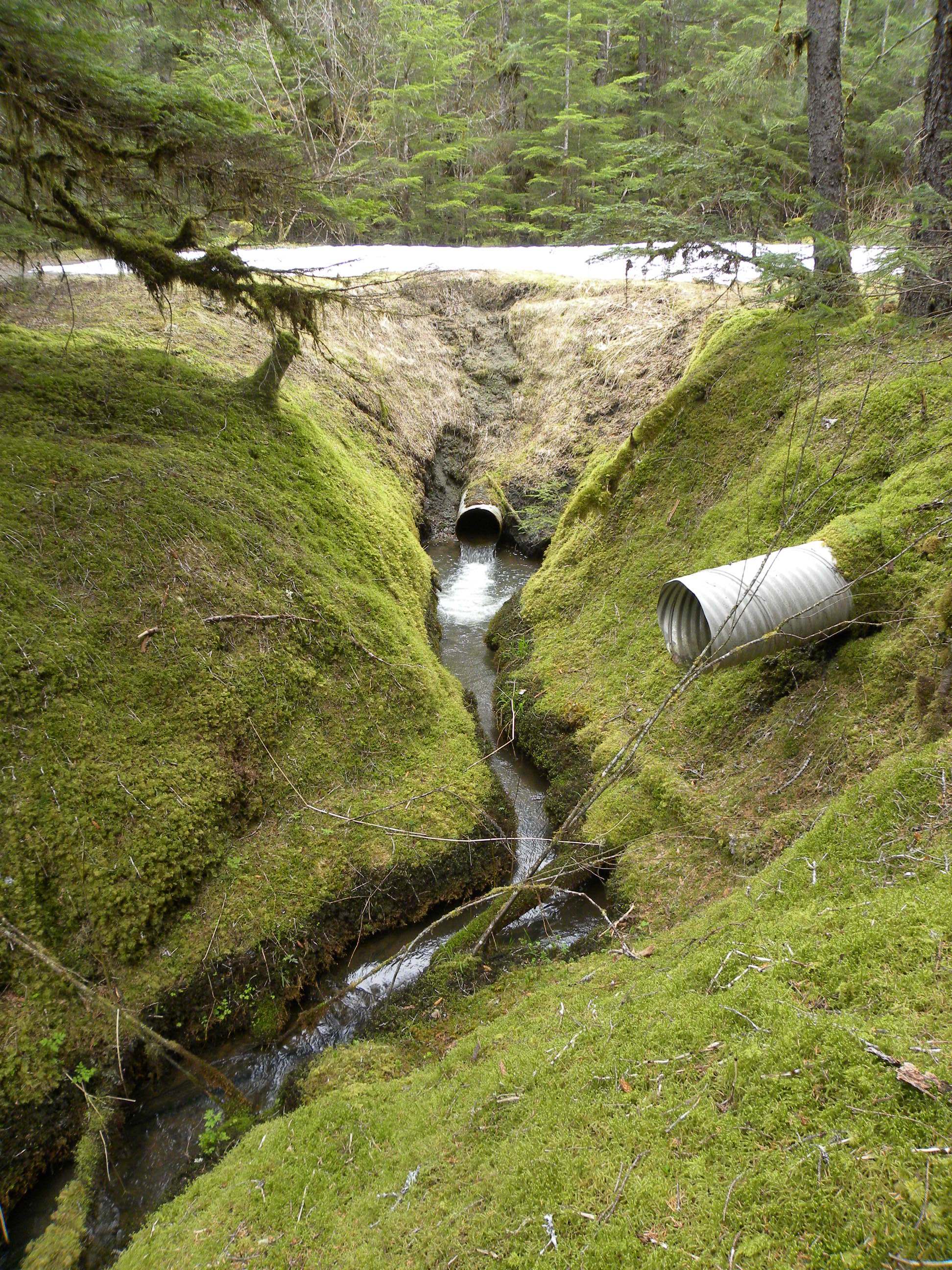
Comments: Undercut at Invert IN. Sandy glide stream incising over time. Possibly influenced by glacial rebound. Visual Observation of juvenile salmonids at outfall pool downstream. Most photos missing. ** Site photos subitted by John Hudson USFWS from 4/25/15 site visit.
Culvert Measurements
| ID: 1 | Structure Type: Circular pipe (Corrugated steel) | Fish Passage Rating: | |||||||||||||||||||||||||||||||||||||||||
|
|
|
|||||||||||||||||||||||||||||||||||||||||
Comments: Bend in pipe. |
|||||||||||||||||||||||||||||||||||||||||||
Culvert Observations:
|
|||||||||||||||||||||||||||||||||||||||||||
Stream Measurements
|
|
| Stream Width Type | Distance From Crossing (ft) |
Stream Width (ft) |
|---|---|---|
| Upstream ordinary high water | 23.0 | 4.40 |
| Upstream ordinary high water | 45.0 | 3.10 |
| Upstream ordinary high water | 89.0 | 1.40 |
Elevations
| Locator ID | Culvert Number |
River Distance (ft)1 |
Distance From Crossing (ft)2 |
Relative Elevation (ft) |
|---|---|---|---|---|
| Road Elev | 108.84 | |||
| D/S Grade Ctrl (Thalweg) | 0.00 | 97.20 | ||
| D/S Water Surface Elev | 0.00 | 97.54 | ||
| D/S Water Surface Elev | 15.00 | 97.56 | ||
| D/S Tailcrest or 1st Thalweg | 15.00 | 96.77 | ||
| Max Pool Depth | 18.50 | 95.77 | ||
| Outlet Pool Water Elev | 18.50 | 97.56 | ||
| Outlet Invert | 22.00 | 98.03 | ||
| D/S Water Surface Elev | 22.00 | 98.20 | ||
| Outlet Culvert Top | 22.00 | 100.01 | ||
| Inlet Culvert Top | 73.30 | 100.23 | ||
| Inlet Culvert Invert | 73.30 | 98.23 | ||
| U/S Water Surface Elev | 73.30 | 98.60 | ||
| U/S Headwater | 74.00 | 98.62 | ||
| Misc. (upstream survey point, on substrate) | 74.00 | 97.61 |
Notes:
- River distance is measured continuously throughout the survey reach along the thalweg of the stream.
- Measured from each end of the crossing along the thalweg of the stream.
Fish Sampling Efforts
| Gear Type: Visual Observation, Ground (A) | Trap Duration(h): 30.0 | |
| Channel Type: Main Channel (>50% of water flow) | ||
| Comments: Visual observation of juvenile salmonids downstream in outfall pool. | ||
| Gear Type: (B) | ||
Fish Observations
| Species: juvenile salmonid-unspecified | Life History: Unknown | ||
| Total Fish Observed: 2 | Fish Measured: | Fork Lengths (mm) Min: Max: Mean: | |
| Collected/Observed by Gear Type: Downstream Visual Observation, Ground (2) | |||
Photos

Questions or comments about this report can be directed to dfg.dsf.webmaster@alaska.gov