Fish Passage Site 10302244
Coordinates (dec. deg.): 58.43981°, -135.67612°
Legal Description: C040S059E04
Region: Southeast
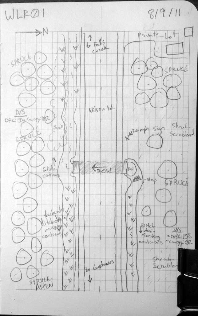
Road Name: Wilson Road
Datum: NAD83
Quad Name / ITM: Juneau B-6
AWC Stream #:
Stream Name: Unnamed
Elevation:
Site Comments: Ditch Drain adj. to Wilson Road
Survey SEA11-WLR01
Project Supervisor: Gillian O'Doherty, Alaska Department of Fish and Game
— Anchorage, AK
Observers: Jason Olds, Charmagne Gutierrez
Overall Fish Passage Rating:
Tidal: No
Backwatered: No
Step Pools: No
Construction Year:
Site Observations:
- Culvert gradient red
- Constriction ratio red
Comments: Stikleback observed DS ditch in the backwater.
Culvert Measurements
| ID: 1 | Structure Type: Circular pipe (Corrugated steel) | Fish Passage Rating: | |||||||||||||||||||||||||||||||||||||||||
|
|
|
|||||||||||||||||||||||||||||||||||||||||
Culvert Observations:
|
|||||||||||||||||||||||||||||||||||||||||||
Stream Measurements
|
|
| Stream Width Type | Distance From Crossing (ft) |
Stream Width (ft) |
|---|---|---|
| Downstream ordinary high water | 12.0 | 4.80 |
| Downstream ordinary high water | 25.0 | 3.60 |
| Downstream ordinary high water | 39.0 | 4.60 |
Elevations
| Locator ID | Culvert Number |
River Distance (ft)1 |
Distance From Crossing (ft)2 |
Relative Elevation (ft) |
|---|---|---|---|---|
| Road Elev | 101.50 | |||
| D/S Water Surface Elev | 0.00 | 98.16 | ||
| D/S Tailcrest or 1st Thalweg | 0.00 | 98.44 | ||
| Outlet Pool Water Elev | 3.00 | 98.16 | ||
| Max Pool Depth | 3.00 | 97.43 | ||
| Outlet Invert | 8.50 | 97.90 | ||
| D/S Water Surface Elev | 8.50 | 98.17 | ||
| Outlet Culvert Top | 8.50 | 100.00 | ||
| Inlet Culvert Top | 39.30 | 100.19 | ||
| Inlet Culvert Invert | 39.30 | 98.11 | ||
| U/S Water Surface Elev | 39.30 | 98.57 | ||
| U/S Grade Ctrl (Thalweg) | 42.00 | 98.76 | ||
| U/S Headwater | 42.00 | 98.93 | ||
| U/S Water Surface Elev | 140.00 | 99.21 |
Notes:
- River distance is measured continuously throughout the survey reach along the thalweg of the stream.
- Measured from each end of the crossing along the thalweg of the stream.
Fish Sampling Efforts
| Gear Type: Visual Observation, Ground (A) | Trap Duration(h): 30.0 | |
| Channel Type: Main Channel (>50% of water flow) | ||
| Comments: Ditch drainage backwater observed sticklebacks downstream. | ||
Fish Observations
No fish observations occurred during this survey.
Photos


Questions or comments about this report can be directed to dfg.dsf.webmaster@alaska.gov