Fish Passage Site 20400035
Coordinates (dec. deg.): 61.20044°, -149.84243°
Legal Description: S013N003W20
Region: South Central
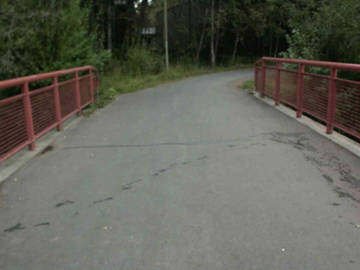
Road Name: Bike Path
Datum: NAD83
Quad Name / ITM: Anchorage A-8
AWC Stream #: 247-50-10050
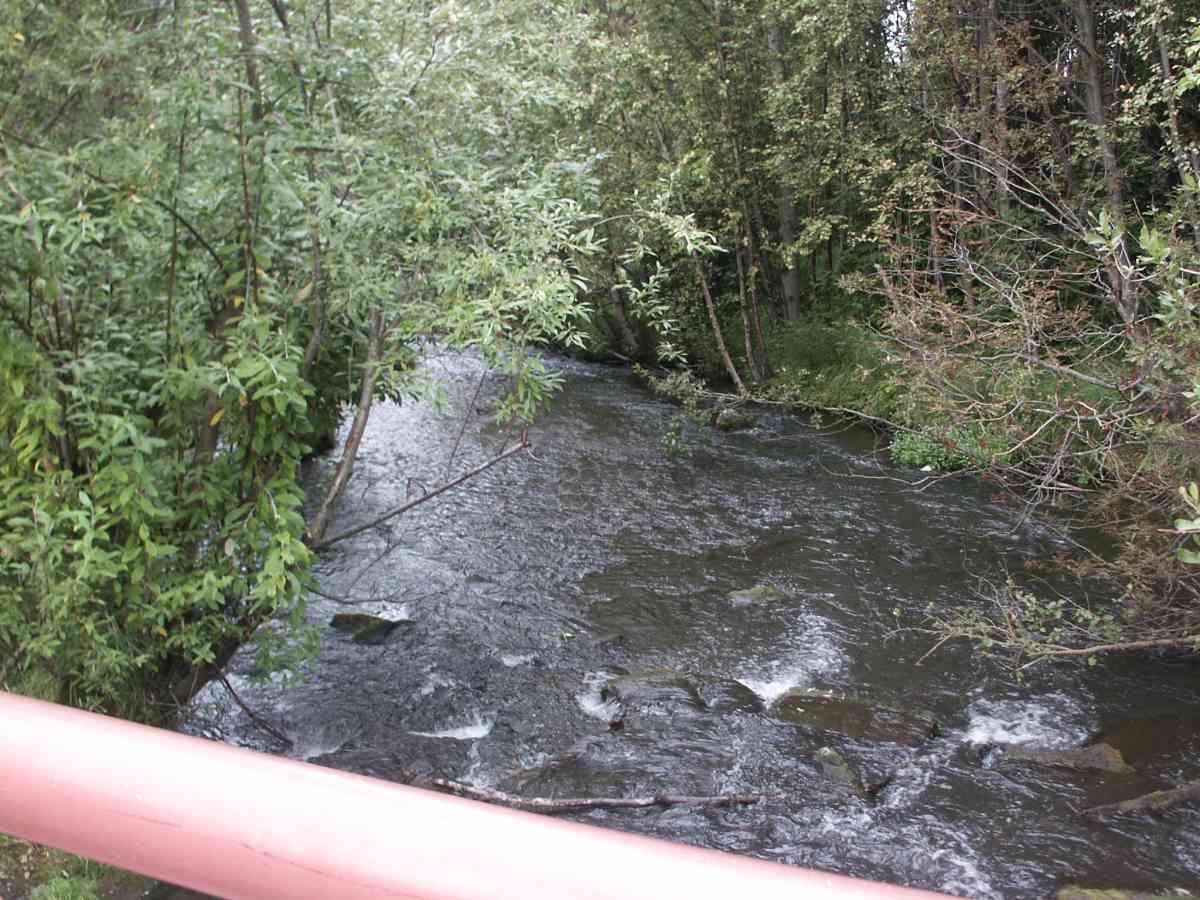
Stream Name: Chester Creek
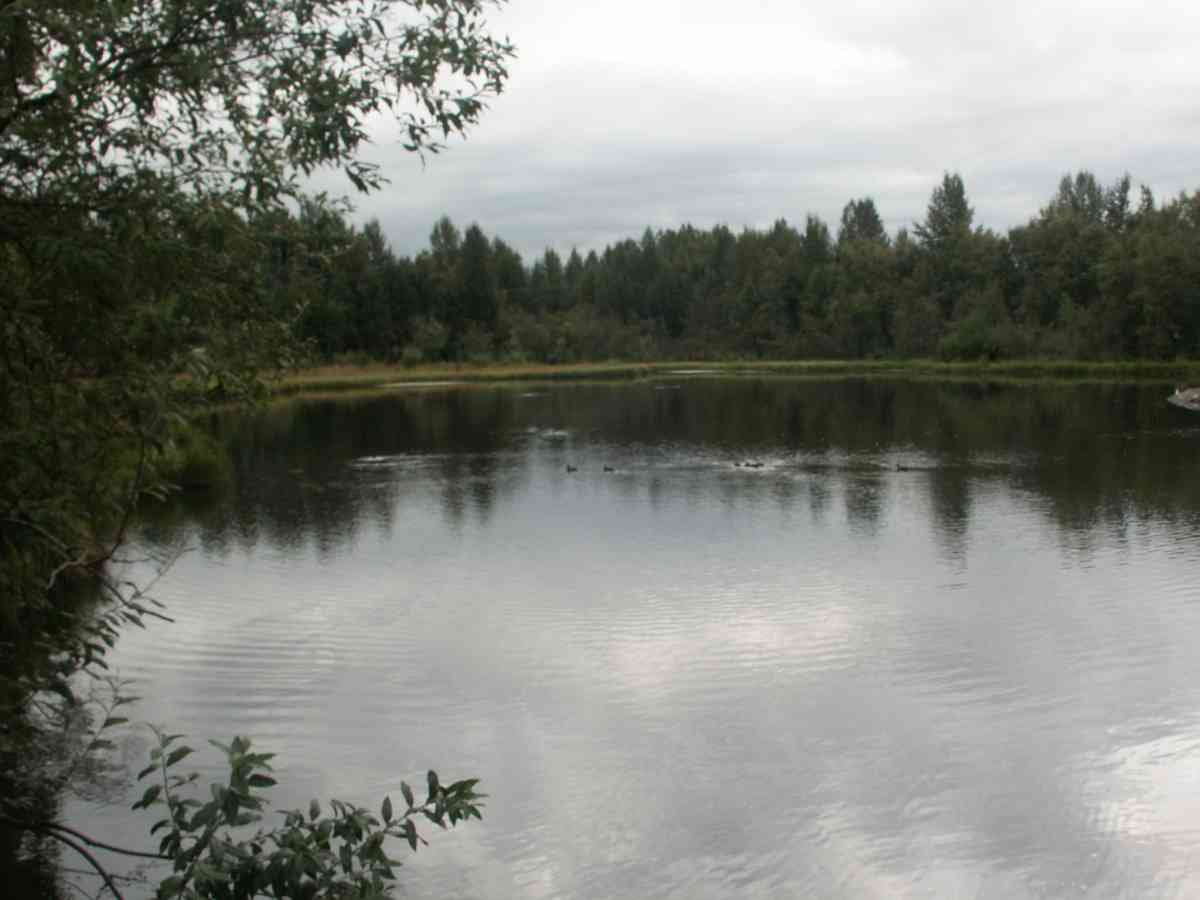
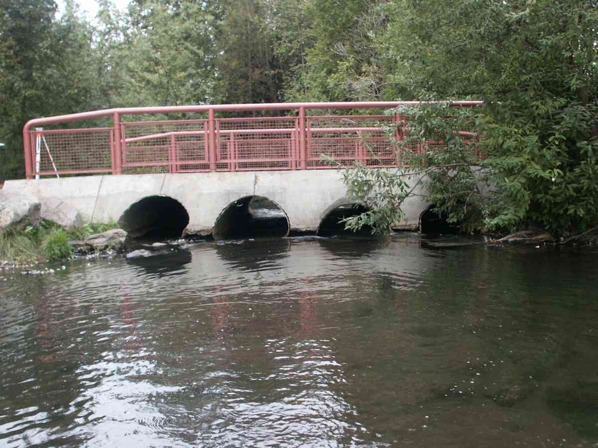
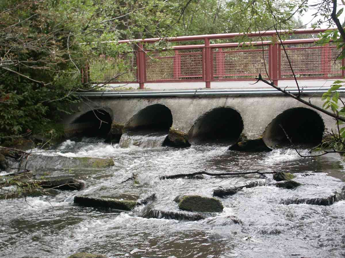
Site Comments: BIKE TRAIL NEAR LAKE OTIS. Four CULVERTS ON CHESTER CREEK UPSTREAM IS A POND, BIKE TRAIL CULVERTS, CHESTER CREEK WATERSHED
Survey Date: Aug 12, 2004
Survey ANC04-2A035
Observers: Dean Beers, Joe Miller
Overall Fish Passage Rating: Red
Tidal: No
Backwatered: No
Step Pools:
Construction Year:
Comments: FOUR CULVERTS ON CHESTER CREEK . INLET INVERT AND OUTLET INVERT ON THE FORTH PIPE ARE 8.66 AND 8.85 RESPECTIVLY. UPSTREAM IS A POND, BIKE TRAIL CULVERTS, CHESTER CREEK WATERSHED
Culvert Measurements
| ID: 1 |
Structure Type: Pipe-arch (Corrugated Metal) |
Fish Passage Rating: |
| |
| Length(ft): 25.6 |
| Inlet Type: Mitered |
| Outlet Type: |
| Corrugation Depth(in.): 0.5 |
| Corrugation Width(in.): 2.67 |
| Condition Rating(1-5): 3 |
| Approach Angle: |
| Sedimentation At Inlet: |
| Inlet Substrate: |
| Outlet Substrate: |
|
| Inlet | Outlet |
|---|
| Width(ft): | 3.6 | |
| Height(ft): | 2.8 | |
| Apron Length(ft): | | |
| Water Depth(ft): | | 0.2 |
| Rustline Height(ft): | 0.7 | |
| Substrate Depth(ft): | | |
|
| Backwatered?: |
| Baffles Present: No |
| Embedded?: No |
| Outfall Height: 0.91 |
| Outfall Type: |
Constriction Ratio: |
| Culvert Gradient: 3.20% |
| Max Slope: |
| Max Slope Length: |
|
| ID: 2 |
Structure Type: Pipe-arch (Corrugated Metal) |
Fish Passage Rating: |
| |
| Length(ft): 24.6 |
| Inlet Type: Mitered |
| Outlet Type: |
| Corrugation Depth(in.): 0.5 |
| Corrugation Width(in.): 2.67 |
| Condition Rating(1-5): 3 |
| Approach Angle: |
| Sedimentation At Inlet: |
| Inlet Substrate: |
| Outlet Substrate: |
|
| Inlet | Outlet |
|---|
| Width(ft): | 3.6 | |
| Height(ft): | 2.8 | |
| Apron Length(ft): | | |
| Water Depth(ft): | | 0.5 |
| Rustline Height(ft): | 0.6 | |
| Substrate Depth(ft): | | |
|
| Backwatered?: |
| Baffles Present: No |
| Embedded?: No |
| Outfall Height: 0.91 |
| Outfall Type: |
Constriction Ratio: |
| Culvert Gradient: 0.85% |
| Max Slope: |
| Max Slope Length: |
|
| ID: 3 |
Structure Type: Pipe-arch (Corrugated Metal) |
Fish Passage Rating: |
| |
| Length(ft): 24.2 |
| Inlet Type: Mitered |
| Outlet Type: |
| Corrugation Depth(in.): 0.5 |
| Corrugation Width(in.): 2.67 |
| Condition Rating(1-5): 3 |
| Approach Angle: |
| Sedimentation At Inlet: |
| Inlet Substrate: |
| Outlet Substrate: |
|
| Inlet | Outlet |
|---|
| Width(ft): | 3.6 | |
| Height(ft): | 2.8 | |
| Apron Length(ft): | | |
| Water Depth(ft): | | 0.3 |
| Rustline Height(ft): | 1.2 | |
| Substrate Depth(ft): | | |
|
| Backwatered?: |
| Baffles Present: No |
| Embedded?: No |
| Outfall Height: 0.91 |
| Outfall Type: |
Constriction Ratio: |
| Culvert Gradient: 2.98% |
| Max Slope: |
| Max Slope Length: |
|
| ID: 4 |
Structure Type: Circular pipe (Corrugated Metal) |
Fish Passage Rating: |
| |
| Length(ft): 24.7 |
| Inlet Type: Mitered |
| Outlet Type: |
| Corrugation Depth(in.): 0.5 |
| Corrugation Width(in.): 2.67 |
| Condition Rating(1-5): 3 |
| Approach Angle: |
| Sedimentation At Inlet: |
| Inlet Substrate: |
| Outlet Substrate: |
|
| Inlet | Outlet |
|---|
| Width(ft): | 3.6 | |
| Height(ft): | 2.8 | |
| Apron Length(ft): | | |
| Water Depth(ft): | | 0.7 |
| Rustline Height(ft): | 0.9 | |
| Substrate Depth(ft): | | |
|
| Backwatered?: |
| Baffles Present: No |
| Embedded?: No |
| Outfall Height: 0.91 |
| Outfall Type: |
Constriction Ratio: |
| Culvert Gradient: 0.77% |
| Max Slope: |
| Max Slope Length: |
|
Stream Measurements
| Stream Substrates | Upstream | Downstream |
|---|
| Dominant: | | |
| Subdominant: | | |
|
| Stream Slope(deg.): | |
|---|
| Stream Flow Stage: | |
|---|
|
No stream width data available.
Elevations
| Locator ID |
Culvert
Number |
River
Distance (ft)1 |
Distance From
Crossing (ft)2 |
Relative
Elevation (ft) |
| D/S Thalweg |
|
|
|
90.76 |
| Max Pool Depth |
|
|
|
91.02 |
| D/S Tailcrest or 1st Thalweg |
|
|
|
91.59 |
| U/S Thalweg |
3 |
|
|
92.21 |
| OHW Left Bank |
|
|
|
92.36 |
| OHW Left Bank |
|
|
|
92.68 |
| U/S Thalweg |
2 |
|
|
92.71 |
| U/S Thalweg |
1 |
|
|
92.82 |
| U/S Thalweg |
4 |
|
|
93.27 |
| Outlet Invert |
4 |
0.00 |
0.0 |
92.57 |
| Outlet Invert |
3 |
0.00 |
0.0 |
92.39 |
| Outlet Invert |
1 |
0.00 |
0.0 |
92.50 |
| Outlet Invert |
2 |
0.00 |
0.0 |
92.32 |
| Road Elev |
|
12.00 |
|
97.07 |
| Inlet Culvert Invert |
1 |
24.00 |
0.0 |
93.32 |
| Inlet Culvert Invert |
3 |
24.00 |
0.0 |
93.11 |
| Inlet Culvert Invert |
4 |
24.00 |
0.0 |
92.76 |
| Inlet Culvert Invert |
2 |
24.00 |
0.0 |
92.53 |
Notes:
- River distance is measured continuously throughout the survey reach along the thalweg of the stream.
- Measured from each end of the crossing along the thalweg of the stream.
Fish Sampling Efforts
| Gear Type: Visual Observation, Ground (A) |
|
Fish Observations
No fish observations occurred during this survey.
Questions or comments about this report can be directed to dfg.dsf.webmaster@alaska.gov