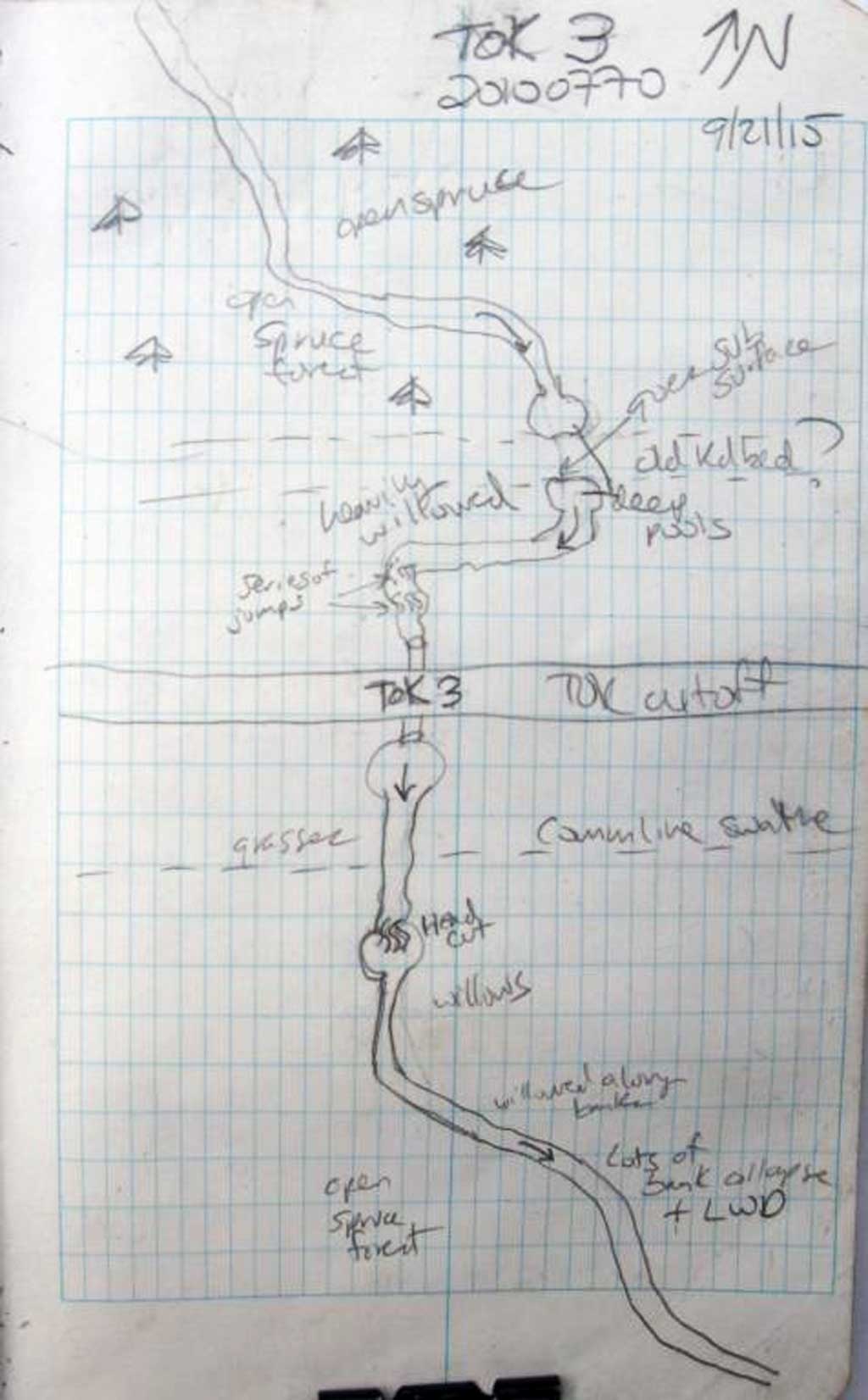
Fish Passage Site 20100770
Coordinates (dec. deg.): 62.65892°, -144.47870°
Legal Description: C010N005E09
Region: South Central
Road Name: Tok Cut-Off
Datum: NAD83
Quad Name / ITM: Gulkana C-1
AWC Stream #:
Stream Name: Copper River Tributary, Unnamed
Elevation:
Site Comments: None
arrow to the right of the survey date below to choose a different report for this site.
Survey UPDATE-TOK3
Project Supervisor: Gillian O'Doherty, ADFG
Observers: Andrew Kastning
Overall Fish Passage Rating:
Tidal: No
Backwatered: No
Step Pools: No
Construction Year:
Site Observations:
- Outfall height gray
- Constriction ratio gray
- Culvert gradient red
Comments: This assessment was performed by the Copper River Watershed Project.
Culvert Measurements
| ID: 1 | Structure Type: Circular pipe (Corrugated steel) | Fish Passage Rating: | |||||||||||||||||||||||||||||||||||||||||
|
|
|
|||||||||||||||||||||||||||||||||||||||||
Culvert Observations:
|
|||||||||||||||||||||||||||||||||||||||||||
Stream Measurements
|
|
| Stream Width Type | Distance From Crossing (ft) |
Stream Width (ft) |
|---|---|---|
| Downstream ordinary high water | 5.10 | |
| Downstream ordinary high water | 3.60 | |
| Downstream ordinary high water | 2.80 | |
| Upstream ordinary high water | 4.20 | |
| Upstream ordinary high water | 2.10 | |
| Upstream ordinary high water | 2.60 |
Elevations
| Locator ID | Culvert Number |
River Distance (ft)1 |
Distance From Crossing (ft)2 |
Relative Elevation (ft) |
|---|---|---|---|---|
| Road Elev | 114.15 | |||
| D/S Thalweg (Bottom of head cut) | 0.00 | 88.97 | ||
| D/S Water Surface Elev | 0.00 | 92.42 | ||
| D/S Grade Ctrl (Thalweg) (Top of head cut) | 4.00 | 95.00 | ||
| D/S Water Surface Elev | 4.00 | 95.35 | ||
| D/S Grade Ctrl (Thalweg) | 40.00 | 96.76 | ||
| D/S Water Surface Elev | 40.00 | 97.36 | ||
| D/S Tailcrest or 1st Thalweg | 61.00 | 97.87 | ||
| D/S Water Surface Elev | 61.00 | 98.16 | ||
| Outlet Pool Water Elev | 70.60 | 98.18 | ||
| Max Pool Depth | 70.60 | 96.34 | ||
| Outlet Invert | 75.20 | 97.95 | ||
| D/S Water Surface Elev | 75.20 | 98.35 | ||
| Outlet Culvert Top | 75.20 | 100.00 | ||
| Inlet Culvert Invert (On pipe) | 164.50 | 100.41 | ||
| U/S Water Surface Elev | 164.50 | 101.06 | ||
| Inlet Culvert Top | 164.50 | 102.44 | ||
| U/S Water Surface Elev | 168.50 | 101.18 | ||
| U/S Grade Ctrl (Thalweg) | 168.50 | 100.68 | ||
| U/S Grade Ctrl (Thalweg) | 175.00 | 101.40 | ||
| U/S Water Surface Elev | 175.00 | 101.90 | ||
| U/S Grade Ctrl (Thalweg) | 181.50 | 101.82 | ||
| U/S Water Surface Elev | 181.50 | 102.53 | ||
| U/S Water Surface Elev | 195.00 | 102.60 | ||
| U/S Grade Ctrl (Thalweg) | 195.00 | 101.54 |
Notes:
- River distance is measured continuously throughout the survey reach along the thalweg of the stream.
- Measured from each end of the crossing along the thalweg of the stream.
Fish Sampling Efforts
| Gear Type: Minnow Trap (A) | Trap Duration(h): 18.0 | |
| Comments: 2 traps set upstream, no fish caught or recorded | ||
| Gear Type: Minnow Trap (B) | Trap Duration(h): 18.0 | |
| Comments: 2 traps set downstream, no fish caught or observed. | ||
Fish Observations
No fish observations occurred during this survey.
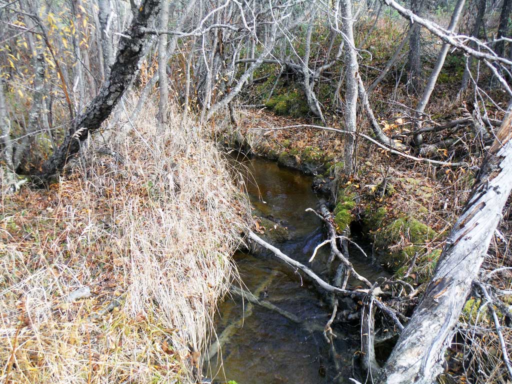
Photos


Questions or comments about this report can be directed to dfg.dsf.webmaster@alaska.gov