MESA Project (Most Environmentally Sensitive Areas)
Oil Spill Contingency Maps
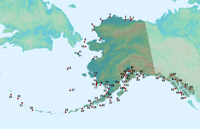
As part of the Alaska Department of Fish and Game’s participation in the review of oil spill contingency plans, the Habitat and Restoration Division (H&R) identified 68 of the most environmentally sensitive areas (MESAs) along the Alaska coastline that could be impacted by a marine spill. This information was originally developed at the request of the Alaska Department of Environmental Conservation (DEC) to assist non-crude oil barge operators in determining whether additional protection strategies were to be included in their oil discharge prevention and contingency plans. These MESAs should not be considered a complete list of highly sensitive areas in Alaska. ADF&G is the source for data in MESA Atlas Volume I. MESA Atlas Volume II depicts data from four sources: ADF&G, NOAA, Dames and Moore Group (URS Corp.), and EMCON Alaska Inc.(SLR International Corp.). The downloadable data on this page contains data from ADF&G and the Dames and Moore Group.
For current ADF&G anadromous fish data visit the Anadromous Waters Catalog — GIS Data page.
For updated NOAA data, visit the NOAA Office of Response and Restoration website.
Work on data from EMCON Alaska Inc. is in progress.
See Oil Spill Contingency Planning: Volume 1 (PDF 72 kB) and Oil Spill Contingency Planning: Volume 2 (PDF 69 kB) for additional information.
Species Shapefiles
You may download species shapefiles individually below, or use the following links to download species shapefiles for Volume 1 (all species) (ZIP file 3,366 kB) and Volume 2 (all species) (ZIP file 5,929 kB).
Species Geodatabase Information
- Download all Volume 1 Geodatabase species information (ZIP file 1,965 kB)
- Download all Volume 2 Geodatabase species information (ZIP file 3,343 kB)
Area Maps
| Location | Map |
|---|---|
| Pribilof Islands (27) | View Map - 485 K |
| Agattu Island (33) | View Map - 474 K |
| Amagat Island (34) | View Map - 426 K |
| Anchorage Flats (48) | View Map - 677 K |
| Barren Islands (42) | View Map - 432 K |
| Buldir Island (32) | View Map - 365 K |
| Burroughs Bay (65) | View Map - 597 K |
| Cape Lisburne/Cape Lewis (6) | View Map - 647 K |
| Cape Newenham/Cape Peirce (17) | View Map - 1,138 K |
| Cape Thompson (7) | View Map - 487 K |
| Chagvan Bay (16) | View Map - 573 K |
| Chenik Head - Silver Beach (43) | View Map - 661 K |
| Chilkat River Flats (60) | View Map - 554 K |
| Cinder River (23) | View Map - 1,198 K |
| Clam Gulch (52) | View Map - 787 K |
| Colville River Delta (3) | View Map - 1,313 K |
| Copper River Delta (57a) | View Map - 1,392 K |
| Copper River Delta (57b) | View Map - 1,066 K |
| Coronation Island (67) | View Map - 419 K |
| Delarof Islands (30) | View Map - 490 K |
| Dry Bay (59) | View Map - 682 K |
| Egegik Bay (21) | View Map - 501 K |
| Forrester Island (68) | View Map - 301 K |
| Goodnews Bay (14) | View Map - 1,399 K |
| Goose Bay (49) | View Map - 438 K |
| Hazy Islands (66) | View Map - 252 K |
| Howe/Duck Islands/Sagavanirktok River Delta (2) | View Map - 727 K |
| Izembek Lagoon (26A) | View Map - 1,052 K |
| Izembek Lagoon (26B) | View Map - 996 K |
| Kachemak Bay (53A) | View Map - 1,204 K |
| Kachemak Bay (53B) | View Map - 1,119 K |
| Kachemak Bay (53C) | View Map - 1,042 K |
| Kagamil Island (29) | View Map - 553 K |
| Kalgin Island (45) | View Map - 421 K |
| Kasegaluk Lagoon (5) | View Map - 770 K |
| King Island (10) | View Map - 378 K |
| Kiska Island (31) | View Map - 644 K |
| Kujulik Bay (38) | View Map - 550 K |
| Kvichak Bay (20) | View Map - 1,511 K |
| Little Diomede Island (9) | View Map - 440 K |
| Marmot Island (41) | View Map - 470 K |
| Mendenhall Wetlands (61) | View Map - 746 K |
| Montague Island (54) | View Map - 589 K |
| Mouth and Lower Kuskokwim River (13) | View Map - 936 K |
| Mouth of Kenai River (51) | View Map - 465 K |
| Mouth of Pack Creek (64) | View Map - 300 K |
| Mouth of the Yukon River (12) | View Map - 1,943 K |
| Noatak/Kobuk River Deltas - Kobuk/Selawik Lakes (8) | View Map - 1,468 K |
| Nushagak Bay (19) | View Map - 1,405 K |
| Palmer Hay Flats (50) | View Map - 797 K |
| Peard Bay/Franklin Spit (4) | View Map - 1,031 K |
| Perenosa Bay-seal Bay (40A) | View Map - 874 K |
| Perenosa Bay-seal Bay (40B) | View Map - 658 K |
| Port Heiden (24) | View Map - 1,265 K |
| Port Moller/Nelson Lagoon (25A) | View Map - 1,176 K |
| Port Moller/Nelson Lagoon (25B) | View Map - 1,485 K |
| Redoubt Bay (44A) | View Map - 846 K |
| Redoubt Bay (44B) | View Map - 680 K |
| Saint Matthew Island (15) | View Map - 457 K |
| Sandman Reefs (35) | View Map - 492 K |
| Seal Rocks (56) | View Map - 297 K |
| Semidi Islands (37) | View Map - 346 K |
| Sheep Bay (55a) | View Map - 583 K |
| Sheep Bay (55b) | View Map - 520 K |
| Shumagin Islands (36) | View Map - 906 K |
| Situk (58) | View Map - 1,017 K |
| St. Lawrence Island (11) | View Map - 956 K |
| St. Lazaria Island (62) | View Map - 369 K |
| Stefansson Sound Boulder Patch (1) | View Map - 1,007 K |
| Stikine River Flats (63) | View Map - 786 K |
| Susitna Flats (47) | View Map - 1,286 K |
| Trading Bay (46) | View Map - 1,147 K |
| Tugidak Island (39) | View Map - 765 K |
| Ugashik Bay (22) | View Map - 1,356 K |
| Unimak Pass/Krenitzin Islands (28A) | View Map - 683 K |
| Unimak Pass/Krenitzin Islands (28B) | View Map - 674 K |
| Walrus Islands (18) | View Map - 980 K |