
Demersal Shelf Rockfish Research
Southeast Alaska & Yakutat Commercial Fisheries
Demersal Shelf Rockfish Research
Yelloweye rockfish biomass is estimated for the annual stock assessment using the following parameters: density, average weight, and habitat area. Rockfish density is estimated from counts along line transects performed by a submersible. Average weight is determined from port sampling the fishery catch. Habitat area estimates are determined from the best available information for an area, which may include National Ocean Survey nautical charts, DSR fishery logbook data, and/or acoustic survey data.
GIS Exploratory Analysis
We are exploring methods using ArcGIS to predict rockfish habitat based on bathymetry data gathered by NOAA and other agencies. This would allow us to have a better proxy of rockfish habitat in areas where we do not have acoustic data.
Yelloweye Rockfish Habitat Prediction Poster Presented at GEOHAB—Sitka, AK 2008 (PDF 561 kB)
Submersible Surveys
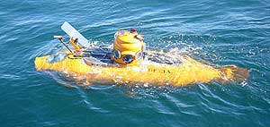
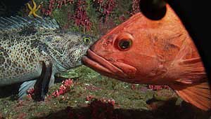
Submersible surveys are performed in outer coast management areas in order to estimate the density of yelloweye rockfish for the annual stock assessment. The objective of this project is to continue a habitat-based method of estimating rockfish abundance as a means to improve rockfish management and to reduce the risk of over-harvest. In addition, we perform fish counts and observations of other groundfish species during submersible dives. Also, submersible dives are used to groundtruth areas surveyed acoustically.