|
||
|
Daniel Teske, Area Management Biologist (907) 465-8152, daniel.teske@alaska.gov |
Area Sport Fishing Reports
Juneau
May 8, 2024
Spring Fishing Opportunities
With the warmer temps and longer periods of sunshine, spring is finally here so it's time to get the fishing gear ready for the upcoming spring and summer seasons! Spring Dolly Varden and cutthroat trout fishing in the estuaries is just beginning, steelhead can be caught and released in area streams (other than Peterson Creek, which is closed) and crabbing for Dungeness and Tanner crab is still good.
Although the harvesting of king salmon is currently closed in the immediate waters around Juneau, there are certainly opportunities coming up soon. The hatchery area will open June 1 and the rest of the marine waters will open June 15. When these areas open, Juneau shoreside anglers can cast large spoons or small herring at locations such as False Outer Point (June 1), Tee Harbor (June 15), and the Breadline (June 15) for king salmon. Marine boat anglers looking to go king salmon fishing in the Juneau area should troll using flashers, spoons, or herring rigs in Fritz Cove, Auke Bay or Lena Cove. Here are some recommendations on king salmon tackle and gear set-ups for both shoreside and marine boat anglers. More ambitious marine boat anglers looking to enjoy the nicer weather and harvest a king salmon before June 1 can do so under regionwide regulations by venturing west of Lemesurier Island in Icy Strait. Just be sure to file a float plan with someone before you leave and be prepared to play cards or cribbage in a safe anchorage if you have to wait for the weather to improve.
Southeast Regionwide King Salmon Sport Fishing Regulations - (OPEN JUNE 15 in Juneau Area)
Alaskan resident:
- The resident bag and possession limit is two king salmon, 28 inches or greater in length;
Nonresident:
- The nonresident bag and possession limit is one king salmon, 28 inches or greater in length;
- January 1st – June 30th, the nonresident annual harvest limit is three king salmon, 28 inches or greater in length;
- July 1st – July 15th, the nonresident annual harvest limit is two king salmon, 28 inches or greater in length; any king salmon harvested from January 1 through June 30 will apply towards the two fish annual harvest limit;
- July 16th – December 31st, the nonresident annual harvest limit is one king salmon, 28 inches or greater in length; any king salmon harvested from January 1 through July 15 will apply towards the one fish annual harvest limit;
- Immediately upon landing and retaining a king salmon, a nonresident must enter the species, date, and location on the back of their sport fishing license or on a nontransferable harvest record;
The Southeast regionwide bag and possession limits above will apply in all areas except as modified below for the inside waters in the vicinity of Juneau:
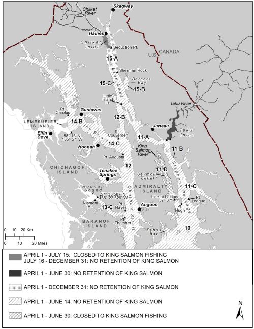
Marine waters near Juneau except Seymour Canal and upper Taku Inlet: (The waters of District 9 north of a line from Patterson Pt. to Pt. Ellis, District 10, Sections 11-A, 11-B, 11-C, District 12, Portion of Section 13-C southeast of a line between Nismeni Pt. and a point on the Chichagof Island shoreline at 57° 35.59' N. lat., 135° 22.33' W. long., Sections 14-B and 14-C, and District 15 south of the latitude of Sherman Rock; see map below)
- April 1 through June 14, 2023: No retention of king salmon. All king salmon caught must be released immediately.
In the waters adjacent to the Taku River:(Taku Inlet north of a line from Point Bishop to Point Greely, see map below)
- April 1 through June 30, 2023: No retention of king salmon. All king salmon caught must be released immediately.
In the waters adjacent to the King Salmon River: (Section 11-D, Seymour Canal north of 57° 37' N. latitude, see map below)
- April 1 through June 30, 2023: closed to king salmon fishing, all anglers may not target or retain king salmon.
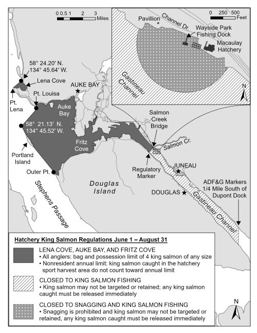
Juneau Hatchery Area Sport Fishing Regulations - OPEN JUNE 1
Take a moment to view the Hatchery King Salmon Regulations map below opening June 1. Please note the closed area in Gastineau Channel. This closure is necessary because the projected return is low and we need as many kings back to the fish ladder as possible to help with future production.
Lena Cove, Auke Bay, and Fritz Cove
Within the designated saltwater hatchery sport harvest area consisting of the contiguous waters of Stephens Passage, Auke Bay, Fritz Cove and Gastineau Channel, enclosed on the west by a line running from the tip of Point Louisa to the navigational aid at the northern tip of Portland Island (58 o 21.13’N., 134 o 45.52’W) then along the eastern shore of Portland Island to its most southern point and ending on Douglas Island at the northern tip of Outer Point, and enclosed on the east by a line extending from the Salmon Creek Bridge to a regulatory marker on the Douglas shore and all salt waters of Lena Cove south of a line from Pt. Lena to a regulatory marker on the mainland shore located at 58o 24.20’N. lat.,134o 45.64’W. long.
- Bag and possession limit of 4 king salmon of any size.
- Non-residents annual limit of king salmon caught in the hatchery sport harvest area do not count toward their annual limit.
Macaulay Hatchery
(DIPAC) is closed to snagging and king salmon fishing. Snagging is prohibited and king salmon may not be targeted or retained. Any king salmon caught must be released immediately.
Gastineau Channel
King salmon may not be targeted or retained and is closed to king salmon fishing. Any king salmon caught must be released immediately from the salmon creek bridge to the ADF&G marker ¼ mile south of Dupont Dock.
Other Spring Fishing Opportunities
Fish Creek and Fish Creek Pond
Anglers are reminded that the daily bag and possession limit for king salmon in all freshwaters crossed by the Juneau road system including Fish Creek and Fish Creek Pond are 4 fish, any size and any king salmon harvested by non-residents do not count toward their annual limit. Please note that within Fish Creek Pond, from June 1 - August 31, anglers may use bait, may snag, and may use weighted hooks, lures, and treble hooks with a gap greater than ½ inch between the point and shank. However, in Fish Creek itself, anglers may NOT use bait, or snag, or use the aforementioned large treble hooks. The marine waters at the mouth of Fish Creek fall under the Terminal Hatchery Area (THA) regulations, and snagging is allowed in salt waters.
Dolly Varden and cutthroat trout Fishing
Till the end of May, anadromous Dolly Varden and cutthroat trout will begin to move into saltwater and will congregate at the mouths of local creeks to feed on emigrating salmon fry and smolts. In particular, Dolly Varden will gather at creek mouths along Gastineau Channel such as Salmon Creek and Sheep Creek, while cutthroat trout will group together at the mouths of Cowee Creek, Fish Creek, and Montana Creek. Using small smolt imitation fly patterns or small spinners and spoons is the best way to catch these fish.
There will also be some fish that do not leave their "overwintering" sites and head for the ocean. Known as "residents", these fish stay in their home lake, pond, or stream the entire year. While these fish may move around in the system to take advantage of food or environmental conditions, they will be present for your fishing all year. Windfall Lake and the Dredge Lakes area are the best locations to find resident Dolly Varden and cutthroat trout.
In all drainages crossed by the Juneau road system, as well as the saltwater adjacent to the Juneau road system to a line ¼ mile offshore, cutthroat and rainbow trout bag limits (in combination) are 2 daily, 2 in possession with a 14-inch minimum and 22-inch maximum size limit. Dolly Varden limits are 2 daily, 2 in possession, no size limit. Anglers should check the 2023 Southeast Alaska Sportfish Regulation Summary for special regulations specific to the stream or lake they intend to fish.
Steelhead Trout Fishing
Steelhead adults will soon begin returning to their natal streams to spawn. On the Juneau road system, Montana Creek and especially Cowee Creek, are the best locations to find steelhead. In Southeast Alaska, most streams that contain steelhead have small annual returns (in the hundreds) and thus can be vulnerable to over-fishing. Retention of steelhead in the Juneau area is prohibited. Any steelhead caught in a drainage crossed by the Juneau road system must be released immediately. Current regionwide regulations elsewhere, away from the road system, prohibit any steelhead under 36" from being harvested and require that a harvest record be completed in ink immediately upon landing a steelhead that is to be harvested. Keep in mind that all fish should be treated with great care regardless of size to ensure the best chances for survival upon release. Please keep fish in the water while releasing. Our website has more advice on proper catch-and-release methods.
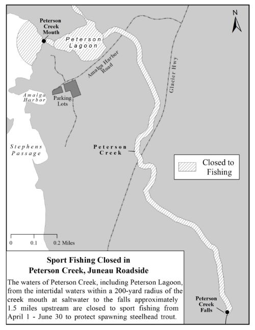
Anglers should note that all sport fishing in Peterson Creek from the falls to the intertidal waters within a 200-yard radius of the creek mouth at saltwater is CLOSED April 1-June 30 to protect spawning steelhead. The Advisory Announcement can be found here and is provided below.
Sport Fishing Closed in Peterson Creek
A portion of Peterson Creek, north of Juneau, is closed to sport fishing for all species. Specific restrictions are as follows:
- The waters of Peterson Creek, including Peterson Lagoon, from the intertidal waters within a 200-yard radius of the creek mouth at saltwater to the falls approximately 1.5 miles upstream are CLOSED to sport fishing from April 1 - June 30, 2024, to protect spawning steelhead.
Based on snorkel survey expansions, in years when concurrent weir counts were available, overall production of steelhead in Peterson Creek has declined in recent years. For the last 9 years (2015–2023), snorkel survey index counts conducted each spring have been below the 1997–2014 average of 28 (equivalent to about 116 fish), when steelhead abundance in the creek appeared to be relatively stable. In 2018, 2019, 2020, 2021, 2022 and 2023 the snorkel survey counts were 6, 3, 11, 24, 18, and 27 fish, respectively. A conservative approach is necessary to manage the Peterson Creek steelhead stock during this period of very low escapements.
For more information, please call the Division of Sport Fish Region 1 office in Douglas at 907-465-4270.
Shellfish Harvesting
Except for red and blue king crab, other shellfish are currently available to harvest. Personal use red and blue king crab fishing is currently closed (beginning April 1), to protect molting and mating crab, but will reopen July 1.
King Crab
Personal use king crab fishing is only open to Alaskan residents. A sport fishing license and a Southeast Alaska Regional Personal Use King Crab Permit are required. These are available at the ADF&G online store. Please check for Personal Use Emergency Orders, legal-size and pot configurations, and restrictions online. Section 11-A is currently CLOSED to Alaskan resident PU king crab fishing. Stay tuned for the Juneau area PU announcement later this year using the link above. Harvest must be reported online. Please check the 2024 Southeast Alaska Sport Fishing Regulations Summary booklet pages 33-36 for regulations specific to shellfish.
Dungeness and Tanner Crab
For Alaskan residents in the Juneau area, licensed anglers can keep 20 Dungeness males, a 6.5" minimum width. While taking Dungeness crab, 5 pots or 10 rings per person may be used, with a max of 10 pots or 20 rings per vessel. While taking Tanner crab, no more than 4 pots or 10 rings per vessel may be used. In total, no more than 5 pots per person and 10 pots per vessel may be used for taking shellfish regardless of pot type.
For nonresidents in the Juneau area, licensed anglers can keep 3 male Tanner and Dungeness crab (in combination). Tanner males need to be 5.5" minimum width and Dungeness males need to be 6.5" minimum width.
Shrimp
Sport and personal use shrimp fisheries in the Juneau and Tenakee area will remain CLOSED until further notice. The closed area consists of all marine waters of Section 11-A north and west of a line extending from a regulatory marker near point Bishop to the Coast Guard marker and light on Point Arden, extending to a line at the latitude of Little Island light, and east of a line from Little Island light to Point Retreat light. And the Tenakee closed area consists of all marine waters in Tenakee Inlet west of the longitude of Corner Point at 135° 06.50' W long. Check the Sport and Personal Use Advisory Announcement,
Outside the Juneau 11-A and Tenakee Inlet areas, sport and personal use shrimp fishing remains open. Sport and personal use shrimpers who have a valid sport fishing license must also have a free shrimp permit available on the ADF&G online store. Participating anglers must sign their permit in ink to make it valid and have the permit in possession while taking shrimp in Southeast Alaska. Shrimp limits and gear requirements for sport and personal use shrimp fishing cab be found on pages 33-36 of the 2024 Southeast Alaska Sport Fishing Regulations Summary. Reporting of effort and harvest is required and must be submitted to the department even if you did not fish.
Clams
Every fall/winter season, the Douglas office gets questions about harvesting clams in the Juneau area. ADF&G does not recommend harvesting clams from any waters in the Juneau area due to the possibility that the clams may contain Paralytic Shellfish Poisoning (PSP) toxins. Currently, no beaches in the Juneau area are monitored on a regular basis (i.e- "certified") for PSP toxins. If you harvest, you do so at your own risk of PSP poisoning. Sporadic sampling has been conducted by the Southeast Alaska Tribal Ocean Research (SEATOR) project, but clams of any species and at any time during the year may still contain toxic levels of PSP. Please navigate to the following Department of Environmental Conservation (DEC) web page for more information about PSP.
Interactive Fishing Location Maps
NEW! Check out the wefishak page on the ADF&G website for the new Juneau-Glacier Bay Interactive Map to discover popular fishing locations and information on species run timing, fishing gear selections, and boat and angler access tips thru the Sport Fish gofishak application.